Apps for the off roader

This site may earn a commission from merchant affiliate
links, including eBay, Amazon, Skimlinks, and others.

Joined
Jan 3, 2007
Threads
2
Messages
5
Hey all.

I'm curious as to what apps for phones or iPads people are using on the trails. I usually study my books then use a GPS to get around but I recently found an app called "every trail" for my phone. It worked good. Took me to the start of the trail and guided me through.

What apps, if any are people using? How are you electronically plotting your journey?

THX
 
I use iTopo, it works pretty well. It has the USGS topos that you can download and then use in case there isn't a cell signal. You can record your track and export it to email in a .gpx file. If I had a 3g iPad, I would try out the backpacker app.
 
For the Droid platform I use Backcountry Navigator. I like it so much it has kept me from switching to an Iphone. For the Iphone/Ipad platform every one seems to think MotionX is the best available.
 
I use motionX on the iPad.
 
For the Droid platform I use Backcountry Navigator. I like it so much it has kept me from switching to an Iphone. For the Iphone/Ipad platform every one seems to think MotionX is the best available.
I really like BCN, as well. Can't be beat for $10!!!
 
Thanks. I'm gonna check these out. I wonder if many people take their iPads with them?
 
gargle said:
Thanks. I'm gonna check these out. I wonder if many people take their iPads with them?

If you had a good mount for it I think it would be awesome. However, without a solid mount I think an iPad would be quite cumbersome to use as a navigator on the trails.

Sent from my HTC Evo using IH8MUD
 
How do these apps compare to, and what is the advantage of them over a GPS with topo maps?
I have a Garmin Nuvi loaded with a bunch of stuff and I now have Galaxy Nexus which is also loaded with a bunch of ham and navigation stuff.
I have been playing with APRSDroid and it works really well.
 
If you want to see an iPad set up check my sig for links.

I use Motion X GPS HD as my main navigation app because it has all of the tools to do the job well. It's super well supported and new features and updates are added all the time. A new version with updated interface and additional map types is imminent.

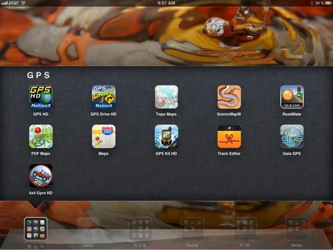
You can see in my screen shot there are several other apps in my iPad, there are several more that I have tried that are not shown.

photo.webp


Droid folks: BCN (i know a couple of you like it) falls short on my Evo 4G compared to some of the iOS apps - Sorry.
photo.webp
 
Last edited:
Another vote for MotionX GPS. I used it on my trip through Death Valley and while crossing the Mojave Road. I downloaded the topo maps ahead of time since I new I wouldn't have service (free to do, but takes forever), then also uploaded the .gpx waypoints provided by Funtreks. Having the topo and the waypoints (and the Funtreks book) was invaluable. All this on a device I already had (iphone) - no need to buy yet another gadget. And the iPhone's GPS antenna worked great, even without a cell signal. Overall, I couldn't believe the functionality I got out of a $3 app!
 
3 for MotionX......

My only hope is that the rumors of it coming to Andriod are true.

I am using the Mapquest on my Galaxy Nexus...nothing to date rivals the user interface of the MX...really miss it.
 
How do these apps compare to, and what is the advantage of them over a GPS with topo maps?
I have a Garmin Nuvi loaded with a bunch of stuff and I now have Galaxy Nexus which is also loaded with a bunch of ham and navigation stuff.
I have been playing with APRSDroid and it works really well.

I have seen gps work where phones fail. if you cant get a signal, a phone app doesn't help much. if you have maps downloaded to the phone, why not just use a map?
 
I have seen gps work where phones fail. if you cant get a signal, a phone app doesn't help much. if you have maps downloaded to the phone, why not just use a map?

I think we could site examples or any technology failing, phone/gps etc so it's always prudent to carry backup or paper map etc. Let me correct you on one point... The apps (iOS / Android) dont require a network signal to receive a gps signal. They can be used as a stand alone GPS and not all apps require downloading of maps, some are onboard the phone/tablet with the app itself. There are a few network dependent navigation apps but were not really discussing that type of program for our purposes.

To answer your question '...if you have maps downloaded to the phone, why not just use a map?" - that's a simple answer: User interface.

If I need to know my postion, Motion X (or any reasonable facsimile) can pinpoint me, continuously and instantly

If I need the distance between two points, motion X can calculate that dynamically and instantly.

If I want to know exactly WHERE I have been to simplify back tracking motion X does it automatically in real time.

Electronic maps are constantly updated

I could go on forever...

Sure a map is a map and doesn't need batteries yada yada.
 
fair points. if the apps work on the gps, and do not requie network connectivity, I can absolutely see how they are beneficial. I was not completely throwing tech out, I did say I have seen gps work where phones were not. the phones must not have had gps driven apps.
 
what would be great if you could purchase a state by state TOPO map loaded on a sim card and then the sim card interfaced wtih the device in question. So you would not have to update or depend on cell signal for map data. Then of course the question is...can all the topo data fit on one sim card for each state. I assume so. This would appeal to me. I would buy the pre-loaded sim cards for the information I needed or areas I frequented and then if by state most of the time I would have sufficient data on hand to avoid having to update or pre-load stuff. Or I assuem you could make you own sim cards by state if you were able to port data of say something like the NG Topo data that comes by state on DVD or other sources.
 
I get the ease of slapping an SD card into something but most devices are cloud or flash based these days... Why not spend some off time and download the maps you need so they are resident and not worry about it anymore?

I know detailed maps take a long time to download but while you are on mud this week you could have downloaded them already. I'm going to Death Valley in a month so I've taken the time preload maps into Motion X GPS HD as well as mark some destination way points. The maps took about 40 minutes to get a mix of 10/15 topo, zoom 15 Bing SAT maps and some Bing road maps. That happened while I was watching a rerun of House MD.
 
For the android user, there is Backcountry Navigator (BackCountry Navigator | Mobile Map Software for Outdoor Recreation) I just found this the other day and its awesome. You can chose from multiple map sources (although the latest version has reduced the overal number). You can save maps to your SD Card so you do not need data coverage to view them.

But most impressive so far is the abililty to load Mobile Atlases, which I have just been starting to mess with. There is a demo version, and a pro version, and the pro version has a ton of map packs you can purchase individually.

I have been spending the past week creating custom maps for all my favorite trails and off-roading areas.
 
is there any way to work with this data on a computer rather than having to interface with the droid phone for all map setup... in other words using BCN and you setup you maps and variables using a large screen or desktop computer and then port or load over to the droid device?

Maybe some people are using a android tablet?


For the android user, there is Backcountry Navigator (BackCountry Navigator | Mobile Map Software for Outdoor Recreation) I just found this the other day and its awesome. You can chose from multiple map sources (although the latest version has reduced the overal number). You can save maps to your SD Card so you do not need data coverage to view them.

But most impressive so far is the abililty to load Mobile Atlases, which I have just been starting to mess with. There is a demo version, and a pro version, and the pro version has a ton of map packs you can purchase individually.

I have been spending the past week creating custom maps for all my favorite trails and off-roading areas.
 

Users who are viewing this thread

Back
Top Bottom