GPS wanted that will work for roads and trails

This site may earn a commission from merchant affiliate
links, including eBay, Amazon, Skimlinks, and others.

Joined
Aug 22, 2003
Threads
30
Messages
401
I don't have a smart phone nor do I want one. I do need a GPS for highway trips. These also often include heading off highway on trails that I find in the area. Have family in Northern CO, close to Steamboat Springs, so I want to have a GPS, besides having maps of the area. It's easy to get turned around and have a hard time figuring out exactly where you are by map. Having a GPS would help to verify, and is easier to watch while driving nice and slow than paper map.

I don't know why there aren't more off road capable GPS on the market yet but I am hoping there is a nice Garmin that will fit my needs. Have used one a few years ago and found it very handy.

What can you recommend for my use? GPS only, no computers or smart phones in this thread please.

Thanks,
 
I user a cheap Garmin Nuvi (1370) with lifetime maps for US roads. Then you just purchase the topo maps and load them onto the same unit. Then you have best of both worlds without computer/phone etc etc.

I have also loaded topo maps of Oz and streetmaps of Oz.

For $100 or so on sale it's cheap enough.

Runs for a few hours on the internal li-ion battery, so you can even use it for short excursions away from the vehicle. Has a decent GPS engine, so gets fixes quickly and rarely loses lock even in down town SF with all the high rise.

cheers,
george.
 
Thanks George. Sounds like a solution that might work for me too.
 
I don't think there is a one-stop solution...for both on and off-road.

There are plenty of on-road options...to include Tom-Tom and others which work well and have a reasonable sized display / screen with a map menu to match. From my experience the good off road GPS units are mainly handheld devices with small screens.

I've asked the same basic question.... as I wanted the same... so far I don't think its out there.

In my case I wanted something that only depends on the GPS signal for nav data and not a cell signal for map data.


Maybe one day we will be able to get a GPS device where you can load topo data using media cards...for the entire state or maybe even a large multi-state area, and then you only have to depend on teh GPS signal for navigation off-road.

For now it seems as if the ipad is one choice... I realize that topo data is quite large...
 
Garmin has topo maps you can load on the Nuvi, that's what I run. Not sure why you think only hand held devices have that capability.

The nuvi takes microsd cards, so not like it is 'capacity' limited.... The garmin topo US 24k series is pretty detailed - versus their topo product.

I use mapsource to choose the specific areas I want to download and that works of US stuff and my Oz stuff as well.

cheers,
george.
 
I have an older Garmin Nuvi 205 with Garmins 24k topo. It works great with both streets and marked trails. But for very detailed off road I use an older Lowrance Global Map 540c with their topo SD card. Like others have said. The Garmin with 24k topo should work just fine for best of both streets and topo.

 
Take a look on Garmin 276c / 376c ( used are no longer available new ) specs .. best on and off road compromise in GPS worls .. personal opinion tho ..

If you like 'em you can look for 'em in eBay . .
 
Garmin Nuvi 205 with Garmins 24K micro SD.


Lowrance with Freedom Maps topo SD.

 
Garmin nuvi 500 has both, had it for years and it's good.

I agree the Garmin Nuvi 500 & 550 are probably the best at on-road and off-road/hiking/boating/geocaching, but unfortunately it's getting a bit dated. I wish they had a replacement.

I recently bought a Nuvi 3760T for on-road, and it's WAY better than my old 265WT in every measurable way.
 
Well....I appreciate all the suggestions. I hope one of these ideas will be implemented soon for my needs. I'll report back when I get it all sorted out and let you know what I decided to do. Several good ideas, including the IPad but I just want a dedicated GPS right now so will probably go with a Garmin like George recommended.

Thanks to everybody for your ideas.
 
Ten inches or go home.

IMG_0439.webp

iPad FAQ TLC FAQ - iPad Navigation FAQ

IPad install in my 100 TLC FAQ - iPad Installed in LC 100
-
-
-
-
-
IMG_0439.webp
 
Last edited:
The OP wants a compact all in one GPS. If you open things up to tablets, then the options of course increase and then if you open it up to Win tablets/computers then you have even more options.

I prefer to run a compact GPS unit since most of the time I want easy confirmation to the tracks I'm on but then when I want real detail I run a laptop since I will cache a few gig of terrain via google earth aerial photography and use a plug in to feed google earth with GPS data from my bluetooth GPS unit.

I'm waiting (maybe forever...) for the day that google allows caching a few gig on their tablet versions of google earth.

I used google earth cached imagery on my last trip to Oz and it was fantastic since it would show recent tracks that aren't on the older topo maps. It also allows you to 'see' anything interesting within reasonable range of where you are that may be worth investigating. Maps are great when you are just trying to figure out where you are or where you want to go (assuming they are recent enough) but it's hard to beat recent/detailed aerial photography when you are exploring.

Choice of GPS/tablet/laptop etc is VERY specific to where you are. In the US there's plenty of quality maps and companies updating those maps, in other parts of the world... not so much.

I bought my first GPS back in 1989 when Magellan released the first consumer handheld GPS unit. It had a single multiplexed channel and cost a hair under $3000. It provided lat/long info and at that time you would need to plan when to use the GPS since there wasn't 24 hour coverage (either 2d or 3d). You had windows of a few hours here and there where you could receive sufficient sats with decent geometry to get a lat/long solution. Then you would take the paper map and locate your lat/long on it. Oh what fun :)

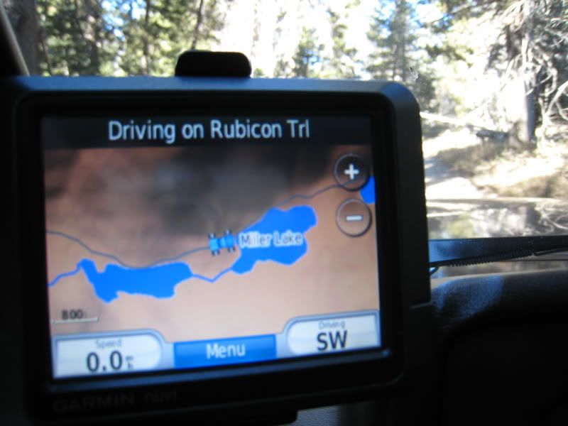
Pre-GPS we would navigate in the bush via maps and dead reckoning and good luck + sense of adventure. We were never lost, rather just unsure of where we were. Lots of adventure and good times. Then with basic GPS and paper maps our world changed, we would now be able to determine accurate positions and be able to choose tracks correctly and a sense of adventure was gone. Finally with integrated maps+gps there is no longer any doubt of where we are and where we're heading and even more of that sense of adventure has been lost. To gain it back we now head to more remote places and often venture cross country as old tracks have faded to nothing in places.

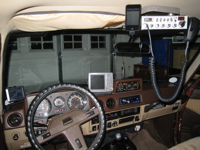
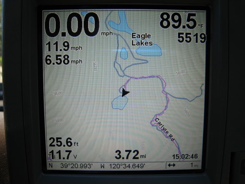
I have several bluetooth gps dongles and one that has integrated memory that can store at least 1000 miles of tracklog (which beats any GPS unit since it's always running in the vehicle and always in my pocket on hikes). I have a tablet with GPS running ozi and androzic, a few handheld GPS units, a few garmin type vehicle GPS units and of course laptops that run ozi and the garmin nroute etc.

On a typical trip I'll have the garmin on the dash, the bluetooth tracker running 24/7 and a laptop and tablet as well. The garmin covers most of the needs, the tablet comes out for access to ozi and topo maps and the laptop comes out if google earth aerial photography is needed. One other issue, at least in Oz, is that different maps have different info. Old topo maps have old fence line info along with various water holes, wells and buildings etc. Newer topo maps have "lost" a lot of that info - I have the conspiracy theory that the oz government/mapping authorities would love everyone to just stay in the city. But the new topos have newer roads/tracks. So, often you can't just rely on one map when really exploring, so a choice of a few maps running simultaneously.

So, in summary, I've not found a one size fits all solution and am happy to range from a couple of inches to a full one footer+ to deal with whatever situation arises :)

cheers,
george.
 
The OP wants a compact all in one GPS. If you open things up to tablets, then the options of course increase and then if you open it up to Win tablets/computers then you have even more options.

True... and In post 16 the OP called out the iPad as a "good idea" and reiterated his dedicated GPS device idea. I happen to know that once you go iPad you wonder why you ever wasted money on a "dedicated" GPS device. I for one have a dedicated iPad for dedicated GPS.

Google doesn't allow cacheing on portables but Bing does.

From Motion X

IMG_0641.webp

IMG_0644.webp
IMG_0641.webp
IMG_0644.webp
 
Back
Top Bottom