alia176
SILVER Star
We spent seven days exploring the northern part of AZ in the Landcruiser. Weather was decent for the most part with a day of rain while we were camping at Toroweap. This campground is at the North rim of GC and worth the effort and fuel to camp there. It has ten sites and my photo album identifies each site. Site #10 is a group site but I don't have a pic as people were there. Below is a Gmap of our stops and route.
1st night
Vermillion Cliffs - found a random spot to camp the first night. It sprinkled a little that night and the following day was cloudy but dry. We drove north to the trailhead for The Wave (permit required, hard to get) and Wire Pass trails. We hiked Wire pass and were blessed with awesome slot canyon. The photo album has bunch of pics and vids of this hike.
Incidentally, when you drive on the House Rock dirt road heading to Wire Pass trailhead, you pass by the California Condor release and viewing site. This area is full of Condors and there were officials present with binoculars and tracking equipment at the site. They were looking for their condors and studying them.
2nd night
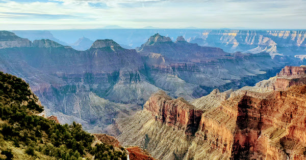
We drove to Jacob Lake to top of fuel and grab a bit before heading to North Rim GC park entrance. We were hurrying to capture some pics at Point Sublime and we weren't disappointed. After grabbing some pics, we went back down to the forest and spent the night before returning early the next morning for sunrise pics. Sunrise at this place is beyond words. Check out the pics to get a flavor of what we saw.
3rd night
We were able to get a permit to stay inside the official park campground and we really wanted a shower. However, the shower was closed for the season so that was a bummer. This campground is all about hikers and they all go to bed early and wake up really early. Tons of trails are in this area and we hiked the Cape Final trail in the late afternoon.
4th, 5th night
Weather was coming and we wanted to take a chance at showing up to the Toroweap campground a day early. After topping off fuel at Fredonia, AZ and getting some groceries in Kanab, UT, we high tailed it for Toroweap. This location is on the edge of the rim and at the end of a 60 mile of dirt road. The last ten miles is a tad rough here and there but doable by most stock 4x4s and taller subarus. As you enter the area, you're greeted by a park ranger who checks to make sure you are 22' max (vehicle+trailer) and that you have a camping permit. They give you a talk of the area and sends you on your way. We were able to secure a spot in the campground and spent two nights there. The sunrises and sunsets from this campground is unsurpassed.
I don't see a need for 22' max length.
6th night
After departing Toroweap, we jumped on Mt Trumbull road and headed to Whitemore hiking trailhead., which was 40 miles away. We passed by the Mt Trumbull single room schoolhouse, Whitmore airfield, Bar 10 resort/ranch before arriving at the trailhead. The last ten miles or so is going across a lava field which is brutal on tires and suspension. We passed a broken down LX470 with a LBJ failure. The driver was walking toward a ranch and asked me to contact his wife to update her on his status.
After hiking down to the Colorado river, we decided not to camp at the trailhead and headed back toward Fredonia. A nice spot was found on BLM land, in the tall Junipers for the night.
7th night
After airing up and topping off fuel at Fredonia, we headed to Flagstaff to visit some friends and spent the night on a driveway. Monday morning found us at the famous Macy's coffee before we hit the road for home.
1500 miles total
approx 250 miles on dirt
This part of AZ is vast and will take few trips to explore. The fall seems to be a good time of the year to go there, maybe Sept would have nice daytime and night time temps. We had some cold nights in the higher elevations. You'll need decent set of tires and ground clearance. I'd say carry at least five jerry cans of fuel to give you that comfort margin. There's no shade so bring your own!
Here's the link to the photo album. If you click on the circle I on top right, you'll see photo description. Lots of pics and vids are included. The videos give you a better sense of what we were feeling at the time.
 photos.app.goo.gl

1st night
Vermillion Cliffs - found a random spot to camp the first night. It sprinkled a little that night and the following day was cloudy but dry. We drove north to the trailhead for The Wave (permit required, hard to get) and Wire Pass trails. We hiked Wire pass and were blessed with awesome slot canyon. The photo album has bunch of pics and vids of this hike.
Incidentally, when you drive on the House Rock dirt road heading to Wire Pass trailhead, you pass by the California Condor release and viewing site. This area is full of Condors and there were officials present with binoculars and tracking equipment at the site. They were looking for their condors and studying them.
2nd night
We drove to Jacob Lake to top of fuel and grab a bit before heading to North Rim GC park entrance. We were hurrying to capture some pics at Point Sublime and we weren't disappointed. After grabbing some pics, we went back down to the forest and spent the night before returning early the next morning for sunrise pics. Sunrise at this place is beyond words. Check out the pics to get a flavor of what we saw.
3rd night
We were able to get a permit to stay inside the official park campground and we really wanted a shower. However, the shower was closed for the season so that was a bummer. This campground is all about hikers and they all go to bed early and wake up really early. Tons of trails are in this area and we hiked the Cape Final trail in the late afternoon.
4th, 5th night
Weather was coming and we wanted to take a chance at showing up to the Toroweap campground a day early. After topping off fuel at Fredonia, AZ and getting some groceries in Kanab, UT, we high tailed it for Toroweap. This location is on the edge of the rim and at the end of a 60 mile of dirt road. The last ten miles is a tad rough here and there but doable by most stock 4x4s and taller subarus. As you enter the area, you're greeted by a park ranger who checks to make sure you are 22' max (vehicle+trailer) and that you have a camping permit. They give you a talk of the area and sends you on your way. We were able to secure a spot in the campground and spent two nights there. The sunrises and sunsets from this campground is unsurpassed.
I don't see a need for 22' max length.
6th night
After departing Toroweap, we jumped on Mt Trumbull road and headed to Whitemore hiking trailhead., which was 40 miles away. We passed by the Mt Trumbull single room schoolhouse, Whitmore airfield, Bar 10 resort/ranch before arriving at the trailhead. The last ten miles or so is going across a lava field which is brutal on tires and suspension. We passed a broken down LX470 with a LBJ failure. The driver was walking toward a ranch and asked me to contact his wife to update her on his status.
After hiking down to the Colorado river, we decided not to camp at the trailhead and headed back toward Fredonia. A nice spot was found on BLM land, in the tall Junipers for the night.
7th night
After airing up and topping off fuel at Fredonia, we headed to Flagstaff to visit some friends and spent the night on a driveway. Monday morning found us at the famous Macy's coffee before we hit the road for home.
1500 miles total
approx 250 miles on dirt
This part of AZ is vast and will take few trips to explore. The fall seems to be a good time of the year to go there, maybe Sept would have nice daytime and night time temps. We had some cold nights in the higher elevations. You'll need decent set of tires and ground clearance. I'd say carry at least five jerry cans of fuel to give you that comfort margin. There's no shade so bring your own!
Here's the link to the photo album. If you click on the circle I on top right, you'll see photo description. Lots of pics and vids are included. The videos give you a better sense of what we were feeling at the time.
AZ Grand Canyon North Rim, AZ strip and Vermillion Cliffs. Oct 2021 · Oct 4 – 10, 2021 📸
Shared album · Tap to view!
photos.app.goo.gl


