High Rock Canyon Run in June (1 Viewer)

This site may earn a commission from merchant affiliate
links, including eBay, Amazon, Skimlinks, and others.

Gallery here:
BBCNN High Rock Canyon 2017 - William Berry

Some highlights, day 1:

Kurt and I went out on the playa to see the mud:


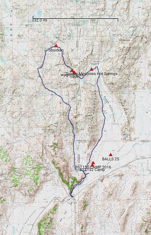
Both 34 and Soldier Meadows Road were recently graded, and allowed decent speeds, so we could catch up with Mark.


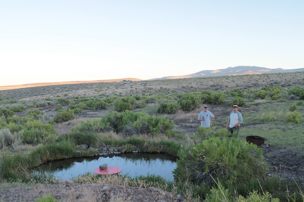
The hot spring camp site has an awesome view, and we could see Loren a few miles out and guide him to the site via radio


Some of the wildlife made me think about not sleeping on the ground


But I did anyway on account of the view


Last edited:
Day 2:

Broke camp and hit the road


First major stop, Fly Canyon and the Potholes


I failed in creating a Toyota Trails cover


but I succeeded in shooting a photo suitable for an outdoor clothing ad


Next up: High Rock Canyon


I cannot decipher the grease grafiti


Here's the cave


and one of the most photographed markings in the area


This little guy tried to bite my eyeball


Time to get moving

 
I was outnumbered by FJs


Looking back along the wagon tracks


Looking forward along the wagon tracks


FJs in the distance


Still a bit of water on the trail


I was having so much fun I forgot to read the sign at this cabin, or shelter, or garage, or whatever


Teeter


I saw antelope several times, but these were the only two that I was quick enough with the camera to capture


Except for this guy


Then a quick stop at the petrified forest


Followed by a creepy feeling that we were being watched


And a fast detour for Loren to get his playa on


Then food and on to home!

 
Great photo write up Will. The outdoor clothing ad was LOL:rofl:. We should have taken some of you and the green beast at work. I had a great time and found out how it is to wheel with air conditioning. Me in the forty will never be the same. It some how felt like I was cheating cause when you wheel your supposed to be hot and dusty:eek:. Thanks for documenting a great memory trip. I feel a sequel coming on someday:smokin:.
 
Last edited:
Looks like a great trip! I found my way here from a reply to a thread I started in another forum about the Applegate-Lassen Emigrant trail. I'm looking into of running this with a some friends this weekend from Cedarville to Imlay (I think). Did you guys run the whole trail or a portion of it? Either way, do you have any insight into whether the full trail is passable? I've left a message with the BLM and plan on calling them again tomorrow.
 
Last edited:
Looks like a great trip! I found my way here from a reply to a thread I started in another forum about the Applegate-Lassen Emigrant trail. I was thinking of running this with a buddy this weekend from Cedarville to Imlay. Did you guys run the whole trail or a portion of it? Either way, do you have any insight into whether the full trail is passable? I've left a message with the BLM and plan on calling them again tomorrow.

It was a great trip! A few photos...

We ran from Soldier's Meadow to Steven's Camp...

BTW, when we chatted with the ranger he thought there was a slide on the portion of road we did... we never saw such. Plenty of water crossings but nothing a stock 4x4 pick-up couldn't handle.
 
Last edited:
Looks like a great trip! I found my way here from a reply to a thread I started in another forum about the Applegate-Lassen Emigrant trail. I was thinking of running this with a buddy this weekend from Cedarville to Imlay. Did you guys run the whole trail or a portion of it? Either way, do you have any insight into whether the full trail is passable? I've left a message with the BLM and plan on calling them again tomorrow.

They only ran a short-ish stretch (compared to that whole run). What you are proposing would be at least a couple long days. Bring your camping gear.
I don't know the whole thing but the biggest issue I see is the stretch across back rock. Refer to the Playa = Lake pictures above. You should be able to go around that part though. I think the best plan there would be to skirt the west side down to Gerlatch and then get on the 49 south of the railroad and take that back out to meet up with the trail again.
 
I advise stay off the playa entirely and take the Soldier Meadows road, or risk a trip ending incident.

Day 1 we side tripped from 12 mile to the mud line and back, after being advised by the BLM ranger that was the safest place to drive out to see the water.

On day 2 we detoured onto the playa from 10 mile (I think) to 3 mile, and that was almost a costly mistake. We felt some punch throughs but kept our momentum.

Even where it appears dry right now there is only about an inch of crust. Because the whole lakebed is saturated beneath that crust, small changes in inflow or small storms on the playa have been causing the mud line to contract some weeks and expand others. And per the conversation with the ranger, winds have pushed the surface water to different areas day to day.

The Soldier Meadows road is in very good shape, it has been repaired and graded after the big winter storms.
 
From the point marked Hot Springs to the point marked Obsidian on this map, took us about 4.5 hours. Another 40 minutes to get onto county road 34. 7 hours total from camp near Soldier Meadows to Gerlach.

 
Last edited:
Thanks so much for the information and recommendations, folks! Looks like we'll definitely steer clear of driving on the playa.
 

Users who are viewing this thread

Back
Top Bottom