
So, me and the chick spent the whole new years day driving out to and running the Santiago Peak trail as taken from the west side of the mountain via highway 74 (Ortega Canyon - Indian Truck Trail via Upper San Juan Campground). Pretty fun trail. Some pretty steep sections, KILLER views (both ocean and mtn and some urban sprawl), but all fire roads. Final stop at the top is at about 5700 feet. It took us 3 hours from North County SD to get to the top, 2:45 home as we went back taking the backside and poping out right at the 15 and heading south. You could do the trail fatser if you haul ass baja style, but we took it slow and enjoyed the views, trail, rig and the fact it is a hop-skip-jump from us in SoCal.
If I were to do it again, I would turn around and go back the way I came rather than take the backside down into Corona. Just more scenic and tougher trail to go back to OC than go down the other side. But, we did not know so it was worth going end to end after peaking out just to see what was doing. Going up from the west side at highway 74 via the camp ground is much tougher, longer, scenic and more beautiful than coming up from the easier backside from the 15.
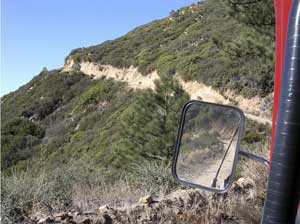
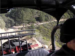
The trail is all fireroad - all along the mountain ridegline. tons of switchbacks, blind turns, short steep grades. Can't realy get lost. Super dooper views and drops. Great final 5700 feet altitude stop at those big TV/radio antennas. Some pretty steep rocky sections (not crawling, just slick shale skree on small rocks cropping out). 4wd seems needed in some sections to be safe. great place to take the chick and scare her now and then with the steep drop offs and sketchy road, but still be safe for the kids/family (assuming you can drive). There was a decent amount of 4x4 traffic that day - I suppose due to the holiday and people with time off... but of all the yeeps we saw, we were the only 40 up there.
The book we use rates it as "moderate" - which is pretty fair because of the steep sections I would say. No tough actual slow rock crawling, just sketchy very steep loose 4x4 fireroad with the potential to take a dive off a steep drop. I would do it again for sure as it is pretty close and scenic. if you need more specific directions, let me know.


If I were to do it again, I would turn around and go back the way I came rather than take the backside down into Corona. Just more scenic and tougher trail to go back to OC than go down the other side. But, we did not know so it was worth going end to end after peaking out just to see what was doing. Going up from the west side at highway 74 via the camp ground is much tougher, longer, scenic and more beautiful than coming up from the easier backside from the 15.
The trail is all fireroad - all along the mountain ridegline. tons of switchbacks, blind turns, short steep grades. Can't realy get lost. Super dooper views and drops. Great final 5700 feet altitude stop at those big TV/radio antennas. Some pretty steep rocky sections (not crawling, just slick shale skree on small rocks cropping out). 4wd seems needed in some sections to be safe. great place to take the chick and scare her now and then with the steep drop offs and sketchy road, but still be safe for the kids/family (assuming you can drive). There was a decent amount of 4x4 traffic that day - I suppose due to the holiday and people with time off... but of all the yeeps we saw, we were the only 40 up there.
The book we use rates it as "moderate" - which is pretty fair because of the steep sections I would say. No tough actual slow rock crawling, just sketchy very steep loose 4x4 fireroad with the potential to take a dive off a steep drop. I would do it again for sure as it is pretty close and scenic. if you need more specific directions, let me know.
Last edited:
 but I guess that never happens to you and all your image posts... from the chat area
