Reno to Toquima Cave the Hard Way

This site may earn a commission from merchant affiliate
links, including eBay, Amazon, Skimlinks, and others.

Joined
Sep 20, 2004
Threads
126
Messages
2,989
Location
Reno, NV
So :princess: and I decided that since we had a free weekend, that we should put it to good use. The idea was to head to central Nevada and into the Toiyabe Range.

We left on Saturday morning and headed east. We stopped in Fallon for breakfast and to fuel up. We made it to Austin to top of the tank and headed south to Columbine Campground, just outside the Arc Dome Wilderness. On the way down, we got to see a Golden Eagle take off from a kill right next to the road. Very impressive.

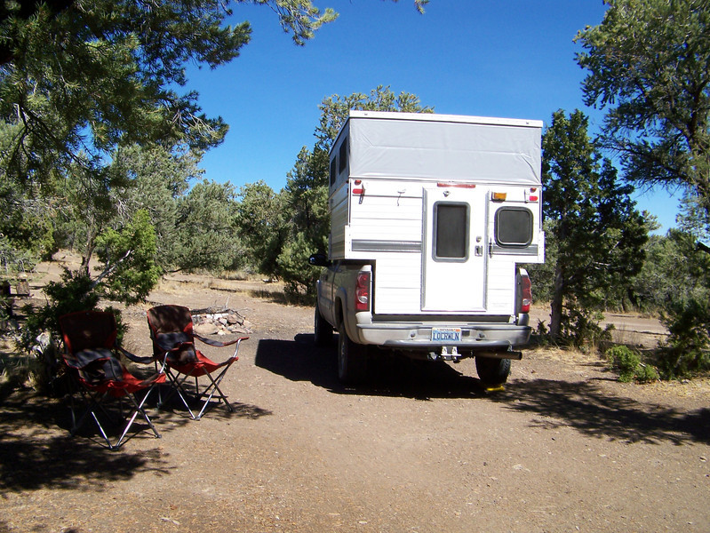
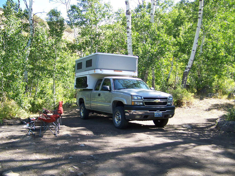
We made it to the campground and found that other than one truck, we had the place to ourselves. We found our spot (the biggest one in the campground), we set up camp, which with the FWC, took all of about 10 minutes from stopping to relaxing. Gotta love that (we do).

Camp:


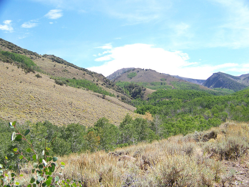
We had the whole afternoon, so we decided to do some hiking. We started up the trail and when we got to the split, we had to decide whether to head for Arc Dome or turn left and follow the Toiyabe Crest Trail. We gave the crest trail a try. Let me tell you, that trail is straight up and unfortunately, covered in cow patties. There are cows everywhere and it kind of ruined the experience. We put in a couple of miles and called it good. We headed back to camp.

Some of the views:


Towards the end of the afternoon, one other vehicle showed up and we talked to him for a while. Had a great dinner and relaxed.

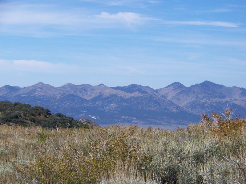
Sunday morning we got up and didn't really feel like going for a hike, so we headed out. Years ago, we had crossed Kingston Summit to the north, and we had made it up to Ophir on the east side of the range (again years ago). We, after seeing other's pics of the Ophir summit, became our destination. To the summit:


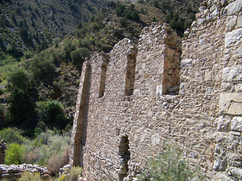
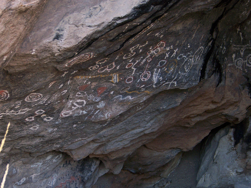
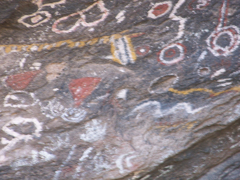
Now things get interesting...

Jack
 
Last edited:
Other's have had the good sense to stop there and turn around...

We (I) didn't.


I looked down the trail and figured, "How bad could it be?" I had been on the lower side and now I had seen the top. Down we headed. At first it was no big deal, just typical Nevada high country roads. And then we hit the jungle. The east side the mountain range in that area is very lush and has an amazing amount of vegitation. Of course the truck and camper were getting their fair share of "Nevada Pinstriping," but it wasn't too bad. Yet. We hit a spot where the spring basically is the road and there were a couple of good holes and I found one. The front passenger side slammed down hard and I knew that I had to have really hit something, but wasn't in a spot to check for damage, just wasn't a good spot, so on we went. Too bad I didn't get a picture of the spot, but took some at the next spot.


Then we came to two dead Aspens laying across the road, they were too low to drive under, so out came the ax. Now for years I have come across low hanging trees that I have had to cut out of the way and you would think that by now, I would remember to pack my bow saw, but I didn't. I started to chop my way through the trunk of the lowest one, which was about 5' off the ground. Not easy to chop through dried Aspen that is 5' off the ground. As I was chopping (slowly) through the trunk, two quads came up behind us. I apologized to them for completely blocking the trail and asked if they had a saw. One guy said he had small saw. I used it and cut right through the rest of the trunk. Got it moved and down we went. I pulled over and let the quads by. The "saw" guy said there was only one other spot and then it was smooth sailing from there. I didn't get any pics of the trees, but just on the other side of the downed trees, there was an old foundation in the vegitation.


We made our way down to Murphy Mine, which was the main source mine for the Ophir area.

Checked the damage and found the front bumper took the hit and it bent the driving light bracket, not too bad.


Some new camper "character."


Being supervised.


Down to Ophir for lunch. After lunch, we decided to head for Toquima Cave. We had passed the turn off many times and figured this was the time. There is a non improved campground just outside the cave area, so that is where we headed. On the way, we scoped out the Spencer's Hot Springs, again, we have known about it for a while, just never stopped. The plan was to camp high and come down in the morning for a soak.

To be continued...

Jack
 
Last edited:
Up to Toquima Cave Campground. We set up camp.


After a bit of relaxing, we had the whole place to ourselves, we headed for the cave. It is only a 1/4 mile walk to the cave.


We took the long way back and spent the rest of the afternoon relaxing and were rewarded with a spectacular star filled sky around 9pm, the moon had not risen yet, so the stars were in full view. We saw plenty of shooting stars, which was really cool. About that time, a Jeep pulled into the entry of the campground, so we ended up with company after all. :D

We got up early and headed down the the hot springs and had a great soak as the sun came up.

Once the soak was over, we headed home. It was a great trip and I would do it again (ok maybe not the east side of Ophir peak road).

Jack
 
Last edited:
Very cool jack!!!
Great write up and pics.
 
thanks for the rock art photos. we've been through that country a few times but never took the time to see the art, next time for sure. i've been day dreaming of columbine lately... i always figured the aspens would be a good show in late october?...
 
Nice write up and photos Jack! Glad I didn't have to come and pull you out of the abyss :D
 
Very cool jack!!!
Great write up and pics.

Thanks. And it was

thanks for the rock art photos. we've been through that country a few times but never took the time to see the art, next time for sure. i've been day dreaming of columbine lately... i always figured the aspens would be a good show in late october?...

No problem, we have driven by there too many times and decided we really had to do it and we are glad we did.

The aspens should be, but we were suprised that even the high aspens haven't started changing yet. So yeah, maybe by late October.

Where is this area? I must go see it :D

Head east to Austin, look at the map, that moutain range. Now head south. It is worth it.

Nice write up and photos Jack! Glad I didn't have to come and pull you out of the abyss :D

Thanks and I am too. But I figured gravity would get me through and it did.:flipoff2:

Jack
 
You can get gas at Austin, as Jack & Darcie did, of course. Or Carvers near Round Mountain in Big Smoky Valley. I think they have gas available in Middlegate...but I can't actually remember as we didn't need to get fuel there...

Other than that its all the way to Tonopah or Eureka.
 
Yeah, we topped up on fuel in Austin and were able to complete all of our wonderings and back to Fallon before fueling up again (could have made it to Reno). If we had left the hot springs and headed up and over Kingston summit, we probably would have stopped in Austin and added some fuel to be sure.

Can't wait to add the lift, tires and larger fuel tank (26g stock, 45 available).

Jack
 
Gabbs should also have gas, it's on the other side of the mountain depending on where you area exploring could be useful.

Could you see Kingston Rsvr? Wondering if it was low and green. Great chukar country too.

Spencer's is a great place to stop and wash up before heading back in for burgers in Austin. It's a little busy for my liking for camping, nevertheless, Sheryl and I honeymooned there before checking out Arc Dome a'horse. There are some real fishy beaver ponds up in there and no way to drive near to them.
 
I think Gabbs has more churches per capita than any town I've ever been in, so it's no surprise the one station in town is closed on Sunday. Trying to remember if it was Gabbs or some other town that had finally put in a pump with a card reader so you could get gas when the station was closed.
 
Last edited:
Credit card accepting gas pumps are one of the greatest inventions of all time.

I hated having to sleep on the street waiting for the morning attendant or worse having to go wake him up at Bruno's hotel and pay the "extra" fee. Still, better than ambushing the gas truck that services remote ranches/mines, wave him down and pay his "extra" fee.

Now, we need to pressure the state legislature to allow the many stations to reopen after they changed the weights/measurements standards and made all the old pumps obsolete. Roughly, I'd say we lost half the rural gas stations, but maybe that's too much. Don't want to start up my soapbox so I'll leave it at that.
 
I think Gabbs has more churches per capita than any town I've ever been in, the one station in town is closed on Sunday. Trying to remember if it was Gabbs or some other town that had finally put in a pump with a card reader so you could get gas when the station was closed.


We wheeled through Gabbs when we were down there in July and we didn't see any commercially available fuel. Maybe I was still 1/2 asleep and needed a second espresso :D
 
We wheeled through Gabbs when we were down there in July and we didn't see any commercially available fuel. Maybe I was still 1/2 asleep and needed a second espresso :D
It's not on the main road, you have to go a block or two off the highway to find it.
 
The Quakies are in full color now, smokie Joe's is only open some times, There is lots more to see in Big smoky Valley. Send me a line and I will answer any questions you have. By the way the beavers have been removed and many of the dams blasted away. There is a great road from Jefferson to Meadow to Barcelona to Silver creek to Manhattan.
 
Back
Top Bottom