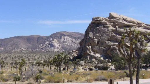
Joshua Tree NP exploring?

This site may earn a commission from merchant affiliate
links, including eBay, Amazon, Skimlinks, and others.

Joshua Tree

Hi guys
Maybe a dead thread, but went to Joshua tree 10 days ago for a one-day ride from LA, and it's an awesome place. We entered thru the Cottonwood springs entrance (ie south) and left at night thru the geological tour trail, a bit more west to the i-10. Bumpy and narrow trail in a somewhat deep canyon, but quite easygoing with my stock FZJ80. No rain there and the trailes didn't seem to have been washed away recently. The arrival on Coachella Valley is more creepy, with rednecks training at gun shooting and burnt car wrecks and garbage, but still worth the journey. Wouldn't really recommend the other way round without a GPS and a lift.
Cheers
Grolar
 
well, would still like to go, maybe even this weekend if the :princess: s can be prodded adequately...

Grolar, what's the "other way around" you meant and why?
 
e9999: well, entering the park through the canyon via an unmarked road in a creepy, full of garbage desert neighborhood! Moreover, the canyon is kind of steep northbound, with a lot of potholes, and divides itself in secondary trails which I suspect lead to dead ends and/or dragon lairs;). Not sure if I could have found my way back. Maybe I'm just a wuss... Anyway, here's a map: the trail is just around the "Joshua" word and below the number 9. Took me one hour and a half-plus southbound. But I suspect the Old dale mining district in the northeast of the Park (already dealt with in this thread) is much more worth the trip. Hope that helps. Cheers. Grolar
jotrmap.jpg
 
if you want to be cheep you go in on glod crown/ old dale road you dont have to pay as theres no ranger at this enterance, also i saw the only tortus i have ever seen walking across old dale road. oh and the hike to lost palms is worth it. also check out barker dam as with this much rain it might still have water in it
 
Barker Dam was still overflowing 10 days ago. Really a very nice place.
 
Hmmm...

Sounds like an interesting place to explore !
 
BTW Rogersfj40: wouldn't recommend trying to cheat on the rangers, they could turn heavy-handed if they catch you:mad:. Even if the admission fee to JTNP climbed from $10 to $15 (for one car, one week) last month, for $50 you can still get a pass for the next 12 months, including the entrance to 380+ Natl Parks countrywide including of course Death Valley (yummy trails), Sequoia and Yosemite, just to mention parks in our range in Southern California. Definitely worth it IMHO. Plus gives you the peace of mind of a good citizen;): priceless! Cheers Grolar
 
rogersfj401969 said:
if you want to be cheep you go in on glod crown/ old dale road you dont have to pay as theres no ranger at this enterance, also i saw the only tortus i have ever seen walking across old dale road. oh and the hike to lost palms is worth it. also check out barker dam as with this much rain it might still have water in it


This kind of attitude irritates me as well.:mad: :mad: :mad: The National Parks are priceless resources that are chronically starved for money needed to keep them going. To try to avoid paying $10 or $20 is criminal, given the thousands of $$ we pay in other ways to go 4wheeling. If you can't afford the $10 park entrance, you can't afford to go offroad. Otherwise, pay up. By far the best policy is to buy a $50 yearly pass. Then you are always legal and you can go anytime you want.
 
Last edited:
i was at UCI for the past 4 years and had to save every $$$$ just to get gas and beer $ to get out there, so the $10 was a big deal to me then. now that i have a JOB i would pay..... but there is no sign telling you to pay, so if the ranger was to find you, i would just pay them.
 
but there is no sign telling you to pay, so if the ranger was to find you, i would just pay them.

Sorry but there are positively some signs asking you to pay along the road in JTNP. I always had good experience with rangers, save once in Yellowstone NP as a student in a speeding car (I wasn't the driver) and my gentle advice would be not to piss them off as they can turn as mean as mean cops;).

However, here's a view of Barker Dam the other day. The first pic is from Hidden Valley. Now you all want to go there:cool: . Besides, the highest mountains around the park are covered in snow right now and the view is a stunner.
Cheers. Grolar

P1000344.webp

P1000352.webp
P1000344.webp
P1000352.webp
 
Ian, it's all about perspective. You only THOUGHT that $10 was a lot or more important than gas or beer. Once you get more years under your belt and all of these places are gone because everyone before your generation didn't give a f@wk, there IS no gas and all you can do is stare into that beer, tell me how expensive it used to be to get into a NP.

Grolar those pics are sweet. :cheers:

And if you really needed to know - that whole area south of the Cottonwood Mtns, east of the town of Coachella, north of the I-10 and west of the Cottonwood Visitor Center entrance road is indeed slated for development. CalTrans is doing the surveys for the onramp/offramp of the new exits now...
 
Thanks for the info Mike. You forgot to mention that all this messy desert development :crybaby: will be just one mile north of the San Andreas fault:D. I can foresee the commercials: "Cottonwood retirement resorts, where you can shake, rattle and roll - even in your late 80s"
 
clownmidget said:
And if you really needed to know - that whole area south of the Cottonwood Mtns, east of the town of Coachella, north of the I-10 and west of the Cottonwood Visitor Center entrance road is indeed slated for development. CalTrans is doing the surveys for the onramp/offramp of the new exits now...

Yes, and if you come off the 10 onto the 62 heading north look to the west and east, both sides have been graded for thousands of new homes in gated communities.
 
well, back from JTNP.
Had a great time!

a few thoughts it that helps:

- now is the perfect time to go. It was sunny, comfortable, nicely warm but not too much. 80F or so tops.
- it's just about impossible to get a spot in one of the central campgrounds on the weekends right now, it's their busiest season apparently.
- Black Rock cmpgrd had some spots on Friday, but Sat was full. It's nice, but not exceptional location wise.
- try for Indian Cove cmpgrnd instead maybe. Has the reservations system, but is in very nice boulders, I'm told, unlike Black Rock. Both are on dead end roads "outside" the park, though. That's a bit of a pain.
- Cottonwood cmpgrnd down south is apparently less busy, and is a good spot to fan out for some wheeling with 2 or 3 trails nearby, but no nice boulders I think.

- I did Old Dale Road. About 25 miles. 4 hrs or so. First 10 miles are sandy trails. Next 5 rocky trails. Last 10 sandy trails again. Easy going except for 2 or 3 miles maybe where the road was in the mountains and had quite a few washouts. Somewhat deep ruts, say a foot and a half or so, and rocks that or less, but nothing that a lifted 80 couldn't do easily if somewhat bumpily. Never needed to stop, back up, or be spotted. Could have done it in a stock 80 too, although with some caution for the worst 500 yds or so to avoid scraping things. Quite a bit of light washboards on the sandy parts. I would strongly suggest to go only with a GPS and some directions; or a very very good map and compass. There were a couple of intersections that one would not know which way to go without directions and/or would be easy to miss. And I'd hate to get lost there. The Backcountry Adventures book has detailed directions. Some old mining remains but not that much. Couple of scarily deep shafts though. We went by our lonesome truck (yea, yea, I know) which was fine, wheeling wise, since the driving was easy, but it would have been uncomfortable to break down out there, even as well-equipped as I was. Only saw 2 or 3 trucks all day Saturday and would not have relished walking 12 miles of desert trails back to the asphalt... There were several abandoned car and truck carcasses left on the side of the road....

- there are another 4 main trails in the park, but didn't have time to do those.

- bouldering on the really big rocks was just a blast!

- spectacular desert scenery!


Recommended if you like the desert!

(and thanks for all the tips above!)


(oh, and there was a poster at the Visitor center advertising a San Bernardino Country supes meeting aiming at limiting 4WD in the deserts...)
 
Last edited:
Glad you had a good time.

We used to camp at Indian Cove when I was a kid. There are some "caves" up in the hills around there. One larger one had a 30' tunnel leading into a 10'x20' cavern which was tall enough to stand in. Not sure if I could crawl through them anymore?

Anyways, glad you guys had fun!
 
calamaridog said:
Glad you had a good time.

We used to camp at Indian Cove when I was a kid. There are some "caves" up in the hills around there. One larger one had a 30' tunnel leading into a 10'x20' cavern which was tall enough to stand in. Not sure if I could crawl through them anymore?

Anyways, glad you guys had fun!
That is where I first learned to Rappell. Keep in mind I was 1500 miles away from my home and didn't really frequent the area. That place is awesome. There were like these oasis that had all this life in it right in the middle of the desert. Awesome place to go climb on rocks.
 
I'm glad you finally made it and had a good time out there.

e9999 said:
(oh, and there was a poster at the Visitor center advertising a San Bernardino Country supes meeting aiming at limiting 4WD in the deserts...)

If I'm not mistaken the meeting is about the dirt bike riding yahoos that tear up private and BLM property out there. As a vacation homeowner in the area I can tell you it is a huge problem with, as usual, a small percentage of them.
 
just a note Indian Cove cmpgrnd has no running water.
 
BTW, e9999, any pics of your trip there? I'd like to wheel in JTNP next week with my stock 80 and was wondering if it could go through Old Dale mining district northbound from Cottonwood. Cheers. Grolar
 

Users who are viewing this thread

Back
Top Bottom