
Just did a rough measurement of Chris' angle and found it between 45 and 50 degrees, assuming the camera is level, and the trees suggest it is. Hard to understand why that truck did not roll!
-
North American Clubhouses - East RegionCA.ON- SOTEC CA.ON- Upper Canada Land Cruisers CA.QC- Club TORQ CA.QC- Quebec Cruisers AL- DixieLand Cruisers AL- Hot South Cruisers FL- Florida Land Cruiser Association FL- Northwest Florida Toyota 4WD FL- Tampa Bay Land Cruiser Association GA- Pavement Pounders GA- Georgia Cruisers GA/FL/AL- Red Hills Land Cruiser Club GA- YOTA IL- Windy City Land Cruisers IN- Hoosier Cruisers IN- Indiana Land Cruisers KY- Kentucky Landcruiser MA/NH- Yankee Toys MI- Lake Michigan Land Cruisers MS- CottonLand Cruisers NC- Olde North State Cruisers NJ- Garden State Land Cruisers NY/CT/MA- FJNortheasters NY- Gotham City Land Cruisers OH- The Buckeye Birfield Syndicate PA- Keystone Cruisers PA- Steel City Land Cruiser Club SC: Land Cruisers: Charleston SC- Palmetto State Land Cruiser Association SC- Upstate Cruisers SC- Swamp Fox Land Cruisers SC- Low Country Land Cruisers TN- Appalachia Cruisers TN- Bluff City Cruisers TN- STLCA VA- Bay to Blue Ridge Cruisers VA- COVA CRUISERS VA/DC/MD- Capital Land Cruiser Club VA/NC- Mid-Atlantic TLCA VA- Star City Land Cruisers VT/NH/MA/ME Acadian Overlanders WI- Land Cruiser Legends WV- Mountaineer Cruisers
-
North American Clubhouses - Central RegionCA.AB- Oil Country Cruisers CA.AB- Rocky Mountain Land Cruiser Association CA.AB- Toyota Ghost Wheelers AR- Razorback Land Cruisers AR/MO- Ozark Mountain Cruisers CO- BookCliff Cruisers CO- Colorado Land Cruisers CO- Derailed Cruisers CO- Rising Sun 4WD Club CO/WY- Horsetooth 4 Wheelers Cruiser Club IA- Tall Corn Cruisers KS/MO- Tornado Alley Cruisers LA- Bayou State Land Cruisers LA- Louisiana Land Krewesers MO- Gateway Cruisers MT- 406 Cruisers MT- Big Sky Cruisers NE- Flat Land Cruisers NM- High Desert Cruisers OK- Green Country Cruisers SD- Dakota Territory Cruisers TX- Alamo City Land Cruisers TX- Bayou City Land Cruisers TX- Lone Star Land Cruisers TX- Lone Star Land Cruisers - Austin Chapter TX- The White Trash of the Elwood Chapter TX- Toyota Trail Riders
-
North American Clubhouses - West RegionCA.BC- Coastal Cruisers CA.BC- Okanagan-Similkameen Land Cruisers CA.BC- Peace Canyon Toyota Swamp Donkeys CA.BC- Calgary Chapter: Swamp Donkeys
CA.BC- Vancouver Island Cruisers AZ- Copper State Cruisers CA- Beach-n-Toys CA- Central Coast Land Cruisers CA- Central Valley Crawlers CA- Gold Country Cruisers CA- Inland Empire Cruisers CA- L.A. County Trailcrew CA- Mountain Transit Authority CA- Pacific Mountain Cruisers CA- San Diego Cruisers CA - Santa Cruz Land Cruisers CA- SoCal 80's CA- Southern California Land Cruisers CA- Toyotally Awesome Cruisers HI- Hawaiian Island Land Cruisers ID- Treasure Valley Land Cruisers NV- Battle Born Cruisers of Northern Nevada NV- Southern Nevada Land Cruisers OR/CA- Jefferson State Cruisers OR- Cascade Cruisers OR- Central Oregon Cruisers OR- Portland Metro Cruisers UT- Red Rock Cruiser Club UT- Wasatch Cruisers WA- Central Washington Cruisers WA- North Sound Cruisers WA- South Sound Cruisers WA- Spokane Land Cruisers
Navigation
Install the app
How to install the app on iOS
Follow along with the video below to see how to install our site as a web app on your home screen.
Note: This feature may not be available in some browsers.
More options
Style variation
You are using an out of date browser. It may not display this or other websites correctly.
You should upgrade or use an alternative browser.
You should upgrade or use an alternative browser.
2013 San Rafael Swell!
- Thread starter jonharis
- Start date
This site may earn a commission from merchant affiliate
links, including eBay, Amazon, Skimlinks, and others.
Excellent pictures as usual. I lost a flip flop on the trail. I was cleaning the Trasharoo and only found one...haha, it was melted anyway from the camp fire.
Not Expo approved footgear anyway!
")
- Thread starter
- #224
Tuesday
Tuesday we departed towards the eastern flank of the Abajos only to end up heading west. Our intended route was up and over Cottonwood Road but a combination of many small factors (snow, vehicle issues) turned us back. We camped near Blanding. Good recovery practice and teamwork.


Tuesday we departed towards the eastern flank of the Abajos only to end up heading west. Our intended route was up and over Cottonwood Road but a combination of many small factors (snow, vehicle issues) turned us back. We camped near Blanding. Good recovery practice and teamwork.
- Thread starter
- #225
Wednesday
Wednesday, we set out for Lockhart Basin. This was the trail that I had concerns about from the initial planning stage since I was hauling my camper. It turned out to be a blast! The scenery was unparalleled and we really felt like we were exploring. Other than a few cars at the very beginning, we didn't see anyone. My kind of trail.
Most of the trail was an easy run, sutable to most stock 4x4s. There were only a few moves that were a little more difficult. The most difficult parts would still be drivable by most stock 4x4s (Toyota's, Jeeps, Rovers etc.) with good tire placement.


At this point we hiked about 1000' to an old airplane crash. Well worth the short hike. Coordinates in the Wells book.


Wednesday, we set out for Lockhart Basin. This was the trail that I had concerns about from the initial planning stage since I was hauling my camper. It turned out to be a blast! The scenery was unparalleled and we really felt like we were exploring. Other than a few cars at the very beginning, we didn't see anyone. My kind of trail.
Most of the trail was an easy run, sutable to most stock 4x4s. There were only a few moves that were a little more difficult. The most difficult parts would still be drivable by most stock 4x4s (Toyota's, Jeeps, Rovers etc.) with good tire placement.
At this point we hiked about 1000' to an old airplane crash. Well worth the short hike. Coordinates in the Wells book.
- Thread starter
- #226
The trail progressivly got harder. If I were in a more stock SUV and concerned about making it I would likely start at the north end. The most difficult part is very close to the intersection with Chicken Corners.


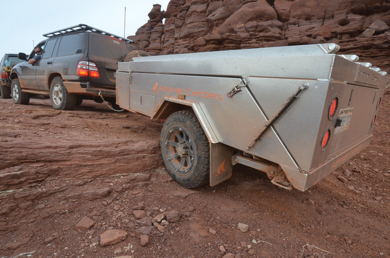


Some Marketing photos for Tuckington Industries


Dropping into the hardest part. Other than being pretty tight it wasn't too bad. I was beyond impressed with the performance of the camper.


This crack requires good tire placement, to far to either side pretty much ensures body damage.


Some Marketing photos for Tuckington Industries
Dropping into the hardest part. Other than being pretty tight it wasn't too bad. I was beyond impressed with the performance of the camper.
This crack requires good tire placement, to far to either side pretty much ensures body damage.
Great pics
Great photos as usual but the night shots are superb. You must have been really busy scrambling around to get so many. Most shots look familiar but I don't remember the crack and it looks like it would be hard to forget. I'd guess a large rock or two rolled onto the trail since I was there in May 2011.
Looking to see the next chapters when more new faces showed up.
Looking to see the next chapters when more new faces showed up.
No that section just looks different in the dark. Its a long section of slickrock that looks like a stream has carved a small canyon in it.
- Thread starter
- #230
Thursday
Thursday morning met us with new friends in the form of three 100 series land cruisers from California and Vegas as well as Crash in his 4RNR. The day would include the most miles covered for the trip on dirt as we had to travel from Dubinky Well to Temple Mountain. A drive through White Wash and the San Rafael Road were on the Agenda.
Dubinkey Well, built by the CCC in the early part of the last century was deeper than most. It's 16' span is larger than most aeromotors seen in the desert. Impressive.
- Thread starter
- #231
Traveling up canyon, the road got progressivly more difficult, ending in a great lunch spot.


Hot lunch on the Trail!


ROCKS!


Coincidence?


Hot lunch on the Trail!
ROCKS!
Coincidence?
- Thread starter
- #232
Green River (town) is the only place where one can cross the Green River (river) so we made our way through. The sleepy town was established in the 1800's by the US mail and grew from there. It became a Uranium mining hub in the 50s-60s. In 1964, the Air Force established the Green River Launch Complex as part of the White Sand's Missle Range. 141 Athena Missles were launched from the location. The base is now abandoned and makes for an excellent side trip. White Elephant, did you guys make it over to the base?


Heading down the dusty, high speed, San Rafael Road.


Camp at Temple Mountain. Can you see the petroglyphs? We couldn't. It turned out to be a pleasant surprise the next morning.

Craig and I doing some night photos.


Heading down the dusty, high speed, San Rafael Road.
Camp at Temple Mountain. Can you see the petroglyphs? We couldn't. It turned out to be a pleasant surprise the next morning.
Craig and I doing some night photos.
Great pictures! This looked like an amazing trip. I'll try not to total my truck before next years trip.
- Thread starter
- #234
Ha. This thread just became our most viewed thread to date.
Friday
Friday was a relatively short drive into Camp followed by some exploring in the southern Swell.


Ouch!

Ouch!


Exploring the mine.


Friday
Friday was a relatively short drive into Camp followed by some exploring in the southern Swell.
Ouch!
Ouch!
Exploring the mine.
- Thread starter
- #235


Lone Warrior


There is a ghost in that Lone Warrior pic. I think its a ghost of the Jon Harris....nice pics.
- Thread starter
- #237
Saturday
Saturday was a great day on the trail with the largest group. Lead by Galen, the group headed down the Devil's Racetrack to the Eva Connover Trail and back to camp. The northern Swell offers very different views than the Southern Swell which keeps things interesting. Camp was a frigid 10 Degrees or so and the huge fire barely kept us warm. Several people left after dinner out of necessity and headed to warmer climates in Moab.


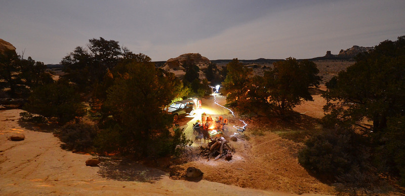
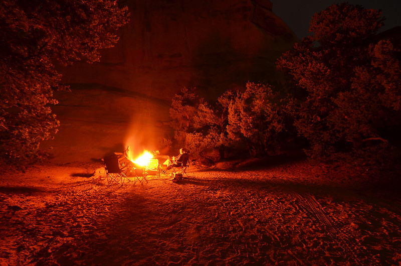
Saturday was a great day on the trail with the largest group. Lead by Galen, the group headed down the Devil's Racetrack to the Eva Connover Trail and back to camp. The northern Swell offers very different views than the Southern Swell which keeps things interesting. Camp was a frigid 10 Degrees or so and the huge fire barely kept us warm. Several people left after dinner out of necessity and headed to warmer climates in Moab.
Waiting for your photos to load I did mow the lawn AND do the laundry. But it was worth the wait!
Ace
Ace
I wonder how much the group will grow for next year's trip.
Great photos Jon. It's hard to really see how steep the drop was that I almost drove my LC off.
I'm looking forward to the time lapse photos!
I'm looking forward to the time lapse photos!