Computer based GPS apps/devices?

This site may earn a commission from merchant affiliate
links, including eBay, Amazon, Skimlinks, and others.

Joined
Jul 20, 2006
Threads
244
Messages
9,502
Location
AL, USA
Hello,

I've noticed that the older I get (late 40's) the harder it is to see the fine print and the harder it its to read the GPS screen on my handheld device (off-road navigation).

While I'm not a techno-wizard, I've noticed that a number of manufactures have come out with various touch screen devices, etc. And there appears to be a good selection of land navigation software (off-road). I do have an old windows based laptop that's not doing anything but collecting dust.

I use my tom-tom for hwy navigation...

Regardlng off-road navigation. What are some proven combinations of device and software application for real time GPS based navigation? Has to be portable (powered by 12volt dc) , stable, and reasonablly affordable. Seems that light weight would be a plus for mounnting solutions etc, idea is to hard mount in the truck.

touchscreen device, laptop device, GPS software, GPS hardware (antenna)...??? Anyone offering a proven combination of hardware/softare/GPS pkgs?

What are others using. Something with a large screen is better, easy to read is great, and affordable is also a bonus.

Any web sites, or product reccomendations would be good.

The idea would be to have the device mounted in such a way that its easily readable / accessible by the driver during off-road situations../driving.

Thanks, Elbert
 
Last edited:
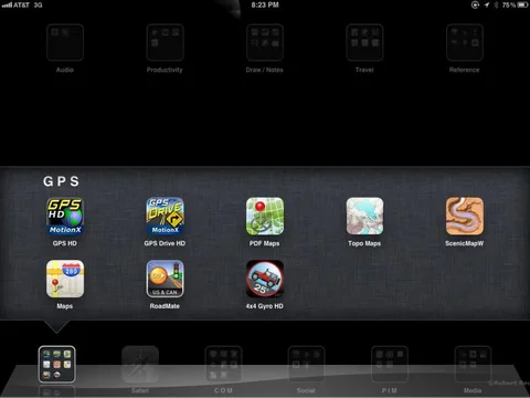
I prefer a tablet solution with self contained GPS. My Choice has been an iPad 3G. Near 10" screen and great application support. I have an android tablet as well but lack of applications prevented me from going there for apps. Apple is of course the premium price at 630 versus 389 for that Asus.

The second shot has my preferred apps for navigation.

IMG_0251.webp

IMG_0332.webp
IMG_0251.webp
IMG_0332.webp
 
I'm looking for something as well. Still want to get a laptop mount for my 62 that can hold my big honkin' ASUS stable, a good USB GPS receiver and a good topgraphic mapping program so I can navigate alot of the old logging roads and trails in western WA (and wherever I go wheeling).
 
I'm running both oziexplorer ($25, for android) and androzic ($0, for android obviously). Both support the same topo maps etc. I have oziexplorer running on my laptop so have all the maps available to copy onto a microsd for the android tablet.

The tablet is a generic android unit $210 and has built in GPS with an external antenna dongle. Works fine and provides a nice big screen that is reasonably viewable in a vehicle during sunny days.

The new Acer A200 looks like a good tablet with fully builtin GPS and a bunch of other nice features (USB, bluetooth, compass etc etc). It's likely the tablet I'd get or the Acer A100 (7"). I have to play with both more to see which makes more sense for MY use.

cheers,
george.
 
Besides OziExplorer, do any of the apps listed allow you to edit tracks, labels, routes, and waypoints, then export to images? Likewise do they allow KML/GPX imports? Can you plan (ie from a hand drawn compound line, can you get a distance/elevation profile?) on the fly?

I still use Natl Geo TOPO! purely because they are beautiful detailed maps (USGS 24k / 100k quad map with NG 500K and larger layers, all unique map data, not zooms), and the map environment is built for you to modify it... not just see where you are and make a waypoint or two. TOPO! is data heavy as each state is basically a DVD- 4-5GB, but for that space you get a lot of history (building locations, "ruins," caves, mines, ranches, springs, waterfalls, and other interesting features) that typically are not included on a smartphone/tablet kind of app.


Just checking in on the status of nav/mapping. Have been at this for years and it astounds me there hasn't been a lot of innovation except showing contours/roads on a map and your location. There has been some interesting custom stuff, like the hunting/fishing $200 map data you can use with a Garmin GPS that shows land ownership and contact info, but not a lot of that out there in general. Craig has done a lot of great stuff with Overland Navigator, like integrating the amateur radio APRS protocol so that stations fade/time-out as you travel (vs TOPO! which just makes a waypoint that stays on the map until you re-open).
 
Anyone taken a close look at the Toshiba Thrive Android Tablet?

I made mention of this is similar thread in this section....


Anyway it looks like these tablet devices boil down to android vs apple os.
 
esh said:
Besides OziExplorer, do any of the apps listed allow you to edit tracks, labels, routes, and waypoints, then export to images? Likewise do they allow KML/GPX imports? Can you plan (ie from a hand drawn compound line, can you get a distance/elevation profile?) on the fly?.

Motion X GPS does most all off that for $2.99. Yes, 3bucks. iPad /iPhone.

Sent from my iPad 2 using IH8MUD
 
Last edited:
P8190004.jpg
 
Acer Tablet

I just installed the Acer Iconia 500 as replacement for a 7" screen win PC running Windows XP. Have been using Ozi for years and it works well on the tablet as on my smartphone.
Using an external bluetooth GPS just for redundancy and because I had it :)

Installation was simple with 3 brackets. VERY sturdy and has proven to be able to handle rough terrain. Tablet can be removed in seconds, the bracket stays in the car.
_mg_5040.webp
_mg_5035.webp
 
What's unfortunate about Ozi Explorer is it relies on a PC to create mapping for the tablet. I can see if you are already a dedicated OE user then it might not be a leap but for others that's a barrier. It also precludes adding maps on the fly. At this point it's a $25 add-on that's still in beta.

bdutch if you decide to come back into the forum post up pics of your mounting - I suspect many would be interested.

Ozi supports a variety of map formats and supports user scanned/calibrated maps. That requires the PC version of Ozi. I'm running both the Ozi and Androzic (free) programs on an Android tablet and I haven't decided which I prefer, they both 'work'.

Since I already have Ozi on my PC and a LOT of maps that are already running on the PC, running the android version (or Androzic) is a simple path to take.

I also log tracks with an all in one GPS/bluetooth tracking device and can then import the data into either platform and can then edit the tracks as needed. I can then load them as background tracks when revisiting areas that don't have those tracks marked on the maps.

So, for my use, the combination of a PC version and tablet version is very useful since I detest using the tablet for anything other than the GPS "display" unit. It's hard to beat the PC with a decent screen (big LCD monitor) and comfort of a real keyboard and mouse and lots of disk storage etc for editing tracklogs, merging them etc etc.

Having used Ozi for many many years, I'm very comfortable with the whole flow and have many maps of various formats that I can utilise.

I look at Ozipc (already own) + Ozi on android (and free androzic) + Android tablet as a cheap entry point versus Ipad (which I don't own) + $3 app. Mapdroyd for free accesses the OSM database and will cache/download maps you request, so that works "ok" for street level stuff

Being able to download maps on the fly in Oz is a feature that would be near useless since there is essentially no cell access other than a few major towns once you get out of the city. Oz trip last year, a two week trip that was just about 1200 miles I had cell access for the first and last days only. That means having to ensure all required maps and aerial imagery needs to be downloaded and prepped before heading off.

I also ran Ozi on a wince device via bluetooth GPS and that was pretty nice and I liked the ability to edit/create my own custom 'pages' for displaying the info I wanted. Looking forward to when that is all functional under the android ozi.

I can see Motion X being nice if a) you live in the US where the map quality is very good, cell access is just about everywhere or certainly within a couple of hour drive and b) you own an Ipad or Iphone. Having lots of choices of a GPS platform is good, since none at present will do everything for everyone.

cheers,
george.
 
Tablet brackets

As requested some pics. I realize that the bracket will never be voted the most aesthetic one, but I have 2 left hands and a friend made it for free. No reason to complain.
2 brackets are screwed in existing holes under the upper side of the dash, the 3rd one in an existing one of one of the vents.
Once the tablet is removed the radio is accessible. A slot on the side ensures access for a USB hard drive.
_mg_5053.webp
_mg_5051.webp
_mg_5052.webp
 
Tablet brackets (cntd)

2 more shots (front view).

As for the software I use Bluetooth GPS (free) to run the service on the tablet for the bluetooth GPS dongle. Can switch to the built-in one though.
Have been using Ozi for years and it suits my needs for the road and excels in use for offroad with satellite maps or scanned topographical maps.
Note that the use of a GPS was still forbidden in Jordan about 3 years ago!
 

Users who are viewing this thread

Back
Top Bottom