If somebody in your group has a laptop computer I'd get a copy of one of the topo map programs and use it in trip planning. I personally use TopoUSA from Delorme. If you decide you want to hit a few national parks then a national parks pass may be the way to go. It'll cover entrance fees for your car and everybody in it and they are good for a year. I never recoup my $ on my Yellowstone trip, but always recoup it by the end of the year.
As for trip time, I always figure two days minimum to Yellowstone as I tend to stop off at places when I get into the high country. I'm only starting from Iowa. If I have planned stops I'll add a day for each. Starting from VA, I'd be tempted to drive through till I got to Wall, SD if going by I-90 or Laramie, WY if going by I-80. I-94 I don't know where the interesting stuff starts.
If you are driving on I-90 past Wall, SD then stop there at Wall Drug. It is a must see tourist trap

. Also take a side trip through the Bad Lands NP there. Coming from the east you can get off at Cactus Flats and make a loop through the Bad Lands and come up out at Wall SD. Along I-90 the Black Hills, Mt Rushmore, and Crazy Horse will also be on your way. Mt Rushmore and Crazy Horse can be seen by taking a moderate length detour off of I-90. Devils Tower NM is a bit off I-90 to the North. For a rock climber or geologist it is a must see stop. Devils tower looks just like it did when the first humans saw it. They know this from studying the lichen on the rocks. None of the fracture columns have fallen in many centuries.
Along I-80 the first real interesting thing is the pass you cross just before Laramie, WY. It is up over 8,600 ft. Then you drop down into Laramie. At Laramie I often take Highway 130 west up over the Medicine Bow mountains and the Snowy Range Pass (10,847 feet). If you do go up over the Snowy Range Pass, travel down the west side and drive some country roads for awhile. Before catching I-80 again. There is some interesting ranch country back there. You'll also see some huge McMansions too. All that is within sight of the west side of the Medicine Bow Mountains.
Beyond Laramie you have a choice. You can enter Yellowstone from the south or east. Both have their pluses. Entering from the south brings you by Grand Teton NP. Entering from the East brings you through Cody, WY. Cody has an excellent cowboy museum. They also have a rodeo that is put on often during the summer. The park entrance road (US 14) to the east was just rehabbed and is maybe the most interesting entrance to Yellowstone. You enter through a big deep river cut. If you go to Cody from I-80, go through the Wind River Canyon just south of Thermopolis. Highway 20 goes through it. I've taken state route 120 from Thermopolis to Cody. Sometime I want to take US 14 to or from Cody tothe east see what it is like along it. I hear the mountains east of there are interesting. When driving the back roads of the west, fill up on gas when you can. Also don't be surprised if there are only credit/debit card pumps and no attendant. There is a lone gas station at Muddy Gap Junction that I have yet to see an attendant at. Not to far west of there (along 287) is Split Rock which is a famous spot on the Oregon Trail. I've often left I-80 at Rawlings and taken various routes off of highway 287. I stuff the tank and my jerry cans in Rawlings and wind my way north or north west depending on where I'm headed. Oh, yeah, I also stuff my water jerry cans. This is very dry parched country. It is all in the rain shadow of Yellowstone and the mountains around it. Not much water falls from the sky there. It will look very different than what you are familiar with. If you decide to drive country roads, be mindful of the cattle. This is open range country. The cattle have access to the roads and them black ones are very hard to see at night. If there is a gate across a road, close it securely after you pass. Most have been converted to cattle guards now, but you may be in sheep country every now and then. Highway 287 leads to Moran Junction in Grand Teton NP. South from Moran Jct is the south half of Grand Teton and Jackson, WY. North is the north half of Grand Teton and Yellowstone NP. From my point of view Grand Teton NP is best at sunrise on a clear day. That is when you get the golden rays of the sun shining on the mountain faces. The rivers in Grand Teton are fishable, I just don't know how good they are.
On going to Yellowstone from Cody. You could go north to the NE entrance. That will bring you close to the Yellowstone end of Highway 212 and the Bear Tooth Pass. State route 296 from State Route 120 to Highway 212 is supposed to be a fun road or so says a lady who lives up in the Colorado Rockies. I haven't been on it yet, but it is flagged as one to travel some day.
You can also get to Cody via highway 14/14A from I-90.
On fishing in Yellowstone, check the notices. Sometimes sections of rivers are closed due to being to warm.

There were many things I was going to do on my first trip to Yellowstone, but I found myself spending many hours ogling and photographing the various landscapes.
I think the most important thing is to know what is along your planned route so you can decide along the way if you have time to do XYZ or not. You got such a long post tonight as I'm working on roughing out possibilities for my next Yellowstone trip this fall. I'm a photographer rather than a fisherman so I tend to look for photographable sites.


 . I guess we should secure a vehicle that doesn't get 15 mpg
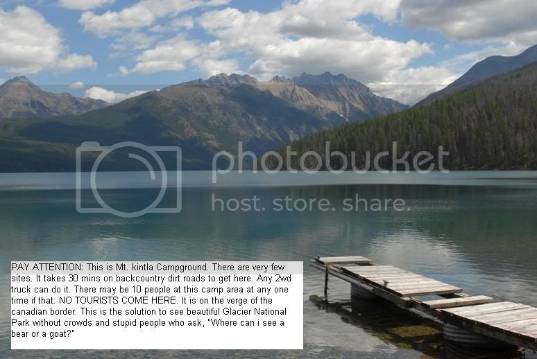
")