As part of the travel management settlement with SUWA, BLM is currently updating 13 travel management plans across the state of Utah. BlueRibbon Coalition was a defendant intervenor in the case, and we have been vigilantly participating in the process of updating the plans. This is a substantial effort, and we have created the 10,000+ Project as a place where members and supporters can join us in the process.
The latest travel management area that is open for public comment in this area is Gemini Bridges and Labyrinth Canyon. This is a map of the area under consideration:
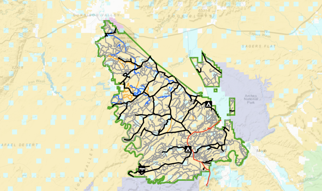
This area is in what is called the scoping period of the process. This basically means BLM is collecting information from the public about which trails should be included in their analysis and which issues should inform their analysis. For an interactive map of the embedded image, use this link: ArcGIS Web Application - https://eplanning.blm.gov/EPLCommentMap/?itemId=2be8bfadeb6a40549e59ad0ad0abb169
The most important part of this step in the process is to make sure that the BLM has a complete inventory of the routes and trails in the area. If this is an area that you are familiar with, you need to review the map using the link to see if there are any important trails missing.
The next issue we can address to make sure our comments have impact is to identify the trails that could be recommended for closure and make sure we justify their continued use. If you use these trails for recreation that is enough of a justification. Usually the trails that will be identified for closure will be trails that get light use and are starting to reclaim with vegetation or trails that look like they have no apparent purpose. For example, many trails have spurs that access overlooks or camping sites. On a map this spur might look unnecessary if we don’t actively justify why it should be left open.
If you don’t know this area as well as others, you can at least make a general comment that BLM should include any additional routes submitted by others and that they should propose an alternative that opens the maximum mileage of routes. We believe the travel management process in Utah will govern over 10,000 miles in trails, and so we will have to fight for every mile during every step of the process to achieve the goal of the 10,000+ Project.
While most people will focus on how travel management affects motorized access to this area, we have found in other areas that those who are trying to restrict access are working harder to restrict dispersed camping than they are working to restrict OHVs. If you enjoy dispersed camping, you need to let the BLM know that they should be looking for ways to increase and manage dispersed camping instead of trying to eliminate it. Moab is a crowded place where hotel rooms and designated campgrounds fill up. This travel management area is surrounded by restrictive National Parks and wilderness areas. With so many acres of land in this area already managed with restrictive access, this is an area where BLM needs to allow multiple use. The fight to eliminate dispersed camping is heating up on public lands, so we created the Dispersed Camping Access Alliance to unite the voice of those who enjoy open, free camping on public land.
If you haven’t already submitted your public comment, hopefully the information in this post helps. You have until April 26 to make a comment if you haven’t submitted one yet. Here is the link for submitting comments: https://eplanning.blm.gov/eplanning-ui/project/2001224/570
Of course we’re planning to submit a comment as well to maintain our legal standing in the travel management process. SUWA is appealing the BLM’s decision to designate hundreds of miles of trails as open in the San Rafael Desert in federal court. We are also consulting on the Trail Canyon plan, which includes trails around Kanab and the Coral Pink Sand Dunes. We’ve submitted comments on several other areas including another area near Moab and the San Rafael Swell. We’re doing everything we can to have a meaningful impact on this process including legal intervention. Any donations made to the 10,000+ Project will be allocated to this effort that will require a lot of time and funding to be effective. We’re going the distance, but we can only succeed with your support.


Continue reading...
The latest travel management area that is open for public comment in this area is Gemini Bridges and Labyrinth Canyon. This is a map of the area under consideration:
This area is in what is called the scoping period of the process. This basically means BLM is collecting information from the public about which trails should be included in their analysis and which issues should inform their analysis. For an interactive map of the embedded image, use this link: ArcGIS Web Application - https://eplanning.blm.gov/EPLCommentMap/?itemId=2be8bfadeb6a40549e59ad0ad0abb169
The most important part of this step in the process is to make sure that the BLM has a complete inventory of the routes and trails in the area. If this is an area that you are familiar with, you need to review the map using the link to see if there are any important trails missing.
The next issue we can address to make sure our comments have impact is to identify the trails that could be recommended for closure and make sure we justify their continued use. If you use these trails for recreation that is enough of a justification. Usually the trails that will be identified for closure will be trails that get light use and are starting to reclaim with vegetation or trails that look like they have no apparent purpose. For example, many trails have spurs that access overlooks or camping sites. On a map this spur might look unnecessary if we don’t actively justify why it should be left open.
If you don’t know this area as well as others, you can at least make a general comment that BLM should include any additional routes submitted by others and that they should propose an alternative that opens the maximum mileage of routes. We believe the travel management process in Utah will govern over 10,000 miles in trails, and so we will have to fight for every mile during every step of the process to achieve the goal of the 10,000+ Project.
While most people will focus on how travel management affects motorized access to this area, we have found in other areas that those who are trying to restrict access are working harder to restrict dispersed camping than they are working to restrict OHVs. If you enjoy dispersed camping, you need to let the BLM know that they should be looking for ways to increase and manage dispersed camping instead of trying to eliminate it. Moab is a crowded place where hotel rooms and designated campgrounds fill up. This travel management area is surrounded by restrictive National Parks and wilderness areas. With so many acres of land in this area already managed with restrictive access, this is an area where BLM needs to allow multiple use. The fight to eliminate dispersed camping is heating up on public lands, so we created the Dispersed Camping Access Alliance to unite the voice of those who enjoy open, free camping on public land.
If you haven’t already submitted your public comment, hopefully the information in this post helps. You have until April 26 to make a comment if you haven’t submitted one yet. Here is the link for submitting comments: https://eplanning.blm.gov/eplanning-ui/project/2001224/570
Of course we’re planning to submit a comment as well to maintain our legal standing in the travel management process. SUWA is appealing the BLM’s decision to designate hundreds of miles of trails as open in the San Rafael Desert in federal court. We are also consulting on the Trail Canyon plan, which includes trails around Kanab and the Coral Pink Sand Dunes. We’ve submitted comments on several other areas including another area near Moab and the San Rafael Swell. We’re doing everything we can to have a meaningful impact on this process including legal intervention. Any donations made to the 10,000+ Project will be allocated to this effort that will require a lot of time and funding to be effective. We’re going the distance, but we can only succeed with your support.
Continue reading...