Two of us went up into the Deep Creek Mountains in NW Utah for a week starting July 11. We were in a stock '94 Cruiser w/o lockers that we have stashed in Las Vegas.
Tuesday: Flew into LV, picked up Cruiser and provisions, headed up Hwy 93 for about three hours to Caliente Hot Springs in Caliente, NV -- a good place to stop after the hassles of flying in. We were advised not to take a shortcut along unpaved Kane Springs Road, which heads NE above Hwy 168 to Elgin and the lower end of Rainbow Canyon -- the road is washed out in places due to serious flash-flood action -- but I want to try it next time; we saw some of the washouts from the north end on our return trip. The desert was pretty baarren just north of LV, but it got better and better the farther north we went. Lots of haze in the air from wildfires, but we didn't see any action.
Caliente is a nice little town at the north end of Rainbow Canyon, which has some wild desert geology and some interesting roads (or drivable washes) going up into fine canyons. Made some dinner, enjoyed the springs, and took off the next morning, along with fire crews that had been staying there.
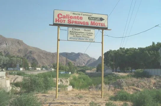
This shot shows the hot springs sign and a faint idea of the springs' buildings to the right. The town is pretty dead, probably because mining activity has been slowing down for decades now, but it's a great jumping-off place.
Wednesday: Headed up 93 through Pioche, a dying mining town that was once a big deal, but now doesn't even have an open grocery store. Turned east and gassed up in tiny Baker; should have done it at the Border Inn, just inside the Nevada border. Over the line in Utah, turned north on Gandy Road, which heads north up the Snake Valley toward the Deep Creeks. Didn't see any snakes, and missed a lot of detail of the mountains due to the smoke in the air. It looks like the Deep Creeks have 8 or 10 good canyons; we had heard good things about Granite Canyon, so we passed up a couple to go there first. Three canyons are actually signed, and Granite's one of them.
The Utah R&R Atlas was a big help to us up there, but it was a little shaky getting us up into the canyon; it's good we had a topo. FYI, the "Y" on the map doesn't really look like a "Y," the Falkenberg Ranch waypoint is now the Douglass Ranch, and there's a cutoff that lets you get to the canyon without going past the ranch. The roads in this range were pretty good, but every so often washouts, deep ruts, big rocks, steep stretches, water, or a combination of these made us glad that we were in the mighty Cruiser. It did everything we asked it to do without a hiccup.
The second shot shows where we camped in Granite Canyon. Like all of the other roads that we went up into the Deep Creeks, the one into this canyon was eventually cut off with BLM signs flagging a wilderness study area. We respected these, but it was clear that not everyone does. Not too many people get up there anyway, and the ones that do generally pick up after themselves.
There were lots of rock shelters and overhangs in Granite and Indian Farm canyons. There were plenty of places where you could wait out a pretty big storm. The third shot shows one that was right in camp. The next morning I discovered a bunch of Indian pictographs back in the shadows.
Thursday: We headed for Tom's Canyon, north of Granite, which we had heard good things about. A ranger had told us that there were washouts on the road. There were plenty of those, but what stopped us was a steep section of rock crawling that clearly required special equipment. We only saw two vehicles in the Deep Creeks the whole trip; the ATV that came bouncing down this hill was one of them. The guy on it confirmed that it's real nice up in Tom's, with meadows and cabins and good fishing, but he was surprised that we had gotten as far as we had. He about tipped over a couple of times himself as he headed on down the hill. This is also the access for Middle Canyon, which has a weird redrock geology that we hadn't seen anywhere else, but the road had a bad angle to it, headed toward a dropoff, so we fanned that one, too.
We decided on Indian Farm Canyon just to the south, which has a shorter approach and lots of granite. It gets real narrow, and has some wild hollowed-out formations that we were surprised to see in granite. Like in all the canyons, we tried to get a good morning and evening hike in to avoid the hot part of the day, and then stayed in the shade or lay in the creek. I haven't said so yet, but the creeks in all the canyons had plenty of good, cold water in them; every so often we could spot snow on some of the 11K' peaks.
Friday: Went north to Trout Creek Canyon. There are several roads shown in the Atlas, but the signed one is the best. The rock in the canyon is brown and very fractured, although it likes to come off in big flakes like flagstones.
I see that I have uploaded the "maximum of 3 files" for my pics, so I have continued this on a second post.
Question: When you attach files to a post, do they all go at the end by default, and if you want to interpolate them with the text you have to stash them somewhere else and reference them with the tag? That's the way it looks to me, so for the moment all of these pics will be at the end of the post.
[ATTACH=full]84665[/ATTACH][ATTACH=full]84667[/ATTACH][ATTACH=full]84676[/ATTACH]
Tuesday: Flew into LV, picked up Cruiser and provisions, headed up Hwy 93 for about three hours to Caliente Hot Springs in Caliente, NV -- a good place to stop after the hassles of flying in. We were advised not to take a shortcut along unpaved Kane Springs Road, which heads NE above Hwy 168 to Elgin and the lower end of Rainbow Canyon -- the road is washed out in places due to serious flash-flood action -- but I want to try it next time; we saw some of the washouts from the north end on our return trip. The desert was pretty baarren just north of LV, but it got better and better the farther north we went. Lots of haze in the air from wildfires, but we didn't see any action.
Caliente is a nice little town at the north end of Rainbow Canyon, which has some wild desert geology and some interesting roads (or drivable washes) going up into fine canyons. Made some dinner, enjoyed the springs, and took off the next morning, along with fire crews that had been staying there.
This shot shows the hot springs sign and a faint idea of the springs' buildings to the right. The town is pretty dead, probably because mining activity has been slowing down for decades now, but it's a great jumping-off place.
Wednesday: Headed up 93 through Pioche, a dying mining town that was once a big deal, but now doesn't even have an open grocery store. Turned east and gassed up in tiny Baker; should have done it at the Border Inn, just inside the Nevada border. Over the line in Utah, turned north on Gandy Road, which heads north up the Snake Valley toward the Deep Creeks. Didn't see any snakes, and missed a lot of detail of the mountains due to the smoke in the air. It looks like the Deep Creeks have 8 or 10 good canyons; we had heard good things about Granite Canyon, so we passed up a couple to go there first. Three canyons are actually signed, and Granite's one of them.
The Utah R&R Atlas was a big help to us up there, but it was a little shaky getting us up into the canyon; it's good we had a topo. FYI, the "Y" on the map doesn't really look like a "Y," the Falkenberg Ranch waypoint is now the Douglass Ranch, and there's a cutoff that lets you get to the canyon without going past the ranch. The roads in this range were pretty good, but every so often washouts, deep ruts, big rocks, steep stretches, water, or a combination of these made us glad that we were in the mighty Cruiser. It did everything we asked it to do without a hiccup.
The second shot shows where we camped in Granite Canyon. Like all of the other roads that we went up into the Deep Creeks, the one into this canyon was eventually cut off with BLM signs flagging a wilderness study area. We respected these, but it was clear that not everyone does. Not too many people get up there anyway, and the ones that do generally pick up after themselves.
There were lots of rock shelters and overhangs in Granite and Indian Farm canyons. There were plenty of places where you could wait out a pretty big storm. The third shot shows one that was right in camp. The next morning I discovered a bunch of Indian pictographs back in the shadows.
Thursday: We headed for Tom's Canyon, north of Granite, which we had heard good things about. A ranger had told us that there were washouts on the road. There were plenty of those, but what stopped us was a steep section of rock crawling that clearly required special equipment. We only saw two vehicles in the Deep Creeks the whole trip; the ATV that came bouncing down this hill was one of them. The guy on it confirmed that it's real nice up in Tom's, with meadows and cabins and good fishing, but he was surprised that we had gotten as far as we had. He about tipped over a couple of times himself as he headed on down the hill. This is also the access for Middle Canyon, which has a weird redrock geology that we hadn't seen anywhere else, but the road had a bad angle to it, headed toward a dropoff, so we fanned that one, too.
We decided on Indian Farm Canyon just to the south, which has a shorter approach and lots of granite. It gets real narrow, and has some wild hollowed-out formations that we were surprised to see in granite. Like in all the canyons, we tried to get a good morning and evening hike in to avoid the hot part of the day, and then stayed in the shade or lay in the creek. I haven't said so yet, but the creeks in all the canyons had plenty of good, cold water in them; every so often we could spot snow on some of the 11K' peaks.
Friday: Went north to Trout Creek Canyon. There are several roads shown in the Atlas, but the signed one is the best. The rock in the canyon is brown and very fractured, although it likes to come off in big flakes like flagstones.
I see that I have uploaded the "maximum of 3 files" for my pics, so I have continued this on a second post.
Question: When you attach files to a post, do they all go at the end by default, and if you want to interpolate them with the text you have to stash them somewhere else and reference them with the tag? That's the way it looks to me, so for the moment all of these pics will be at the end of the post.
[ATTACH=full]84665[/ATTACH][ATTACH=full]84667[/ATTACH][ATTACH=full]84676[/ATTACH]
Attachments


Last edited: