Mojave Rd. April 15-17 2011

This site may earn a commission from merchant affiliate
links, including eBay, Amazon, Skimlinks, and others.

There are no facilities at the campsites we are visiting as far as I know Mark, only Mid Hills and Hole in the Wall have toilets . Ollie sent out a revised GPX file. What is a navi file, I remember seeing that term on the navigation system for a motor-home we rented?


http://www.nps.gov/moja/planyourvisit/camping-regs.htm

3. Dispose of Waste Properly

Store all food and garbage in a manner that will prevent access by wildlife. Carry plastic bags and pack out all trash.
While LNT guidelines suggest burying human waste, the fragile nature of the desert ecosystem has prompted managers to implement a policy of removing all human waste. Please pack out what you bring in.

OK, no problem that's what I thought.

Oh and I just meant Navigation because I couldn't remember the letters for the specific file types.
 
Mark,

I know you just got a new Delorme program. I have a Delorme program too. I'm going to send out another email tonight or tomorrow. We had someone else drop back in and he needs the file(s) too. I'll attach a few types of files. GPD (Garmin Data Base), TPO (TOPO 4.0), GPX (GPD Exchange Format), and TPX (Delorme File).

Mid Hills Campground (Friday night's camp) does have facilities. They vault toilets as I recall. Saturday night's site is primitive. You can haul it out or bury it.

Hmmm, I am looking at my Topo 9.0 software right now and when I select transfer import or create it only displays a .dmt in the pull down for file types. Oh well I guess I will try it when I get a file from you.
 
Hmmm, I am looking at my Topo 9.0 software right now and when I select transfer import or create it only displays a .dmt in the pull down for file types. Oh well I guess I will try it when I get a file from you.

Mark -

Try right clicking on the navi file (pc not mac) and choose "open with". Choose the Delorme exe file/program to run your "navi" file. Hope that works?
 
I use the 6.0 version of Delorme. On mine, when the program is open, I go down to the bottom of the screen and click on the "Draw" tab. Then on the right hand side I go to "Import" then select the GPX file that's on my hard drive that I want to open. The program then embeds the tracks and waypoints into the TOPO map.
 
I use the 6.0 version of Delorme. On mine, when the program is open, I go down to the bottom of the screen and click on the "Draw" tab. Then on the right hand side I go to "Import" then select the GPX file that's on my hard drive that I want to open. The program then embeds the tracks and waypoints into the TOPO map.

That's awesome Ollie, I have Delorme 7.0 and the instructions you gave work perfect and it allows me to see all the formats that the program accepts.

Did you upload any additional maps or charts for the area? The OEM Delorme TOPO map is horrible when you are zoomed in, basically you get nothing. I uploaded the SAT 10 imagery and it's decent but expensive. Any suggestions?
 
Last edited:
Hmmm, I am looking at my Topo 9.0 software right now and when I select transfer import or create it only displays a .dmt in the pull down for file types. Oh well I guess I will try it when I get a file from you.

Mark-

If Ollie's suggestion does not work just call the Delorme support number, they are very helpful if you have current software.They are in Maine so call early.

Technical Support - for installation and other support
Phone: 1.207.846.8900
Hours: Mon-Thurs 8:30am-5:00pm EST, Fri 9:00am-5:00pm EST
 
That's awesome Ollie, I have Delorme 7.0 and the instructions you gave work perfect and it allows me to see all the formats that the program accepts.

Did you upload any additoinal maps or charts for the area? The OEM Delorme TOPO map is horrible when you are zoomed in, basically you get nothing. I uploaded the SAT 10 imagery and it's decent but expensive. Any suggestions?

Scott,

I haven't loaded any additional maps other than what I got with the program (which you turned me onto during our last Mojave trip BTW). It sounds to me like you might be running the Delorme City Program and not TOPO. I could be wrong though. The program I have is Delorme TOPO 6.0. It shows contour lines and all that stuff. It's city streets are limited but it does do routing on highways. I like Delorme and I use it to track while I'm in the dirt but I have found that programs like National Geographic TOPO 4.0 (actual USGS maps) show a lot more detail and points of interest. They even have handwritten notes from when they did their last surveys back in '78. Some of the waypoints yousee in there are pulled off of the TOPO 4.0 program and the items I have reference don't even show up on the Delorme or Garmin mapping TOPO software. You can track with TOPO 4.0 but it isn't nearly as robust and it's clunky.

When I create routes and plan trips, whether hiking or offroading, I use TOPO 4.0, Google Earth, and Delorme for reference tools and then transfer waypoints and data into my Garmin Mapsource to create tracks and gpx file. After I have the gpx file I can import it into any of my other programs. A lot of programs will not allow you to export a track. They make you export as bread crumbs (a track of waypoints). I don't like that. I like a solid line to follow instead of going point to point. I have missed turns going point to point and when you are hiking a track is much more friendly to follow because of the slow rate of speed you are traveling.

You will note the different colored tracks in the file I sent you. The red track is the primary route. They yellow tracks are the optional sites we can try based on our time constraints. I want to try and hit several of the yellows. We'll see...
 
yeah I'm still in I get off work at 4:30pm on Thursday. I'm solo so I'll be down to roll out whenever on Friday. Don't really have a lot of stuff so I could probably help carry firewood.
 
Nope, sent you an e-mail.

I downloaded the .tpx file because that was what is compatable with my software but it had an error for both draw files. I need a .ap2 files for draw files.

Gotta say this software is really frustrating and on my own map I have only been able to punch in 3 points while I can make a kick A$$ google map as you can see from my earlier posts. Wish I could just transfer my google maps file into my Topo 9.0 software. :mad:
 
Nope, sent you an e-mail.

I downloaded the .tpx file because that was what is compatable with my software but it had an error for both draw files. I need a .ap2 files for draw files.

Gotta say this software is really frustrating and on my own map I have only been able to punch in 3 points while I can make a kick A$$ google map as you can see from my earlier posts. Wish I could just transfer my google maps file into my Topo 9.0 software. :mad:

Call the phone number I gave you, they will help you out.


Technical Support - for installation and other support
Phone: 1.207.846.8900
Hours: Mon-Thurs 8:30am-5:00pm EST, Fri 9:00am-5:00pm EST
 
OK, just got off the phone and what I needed was to go to the draw tab and import your .gpx file and whala.... You would think you would just be able to click on your .tpx file but I guess not.
Now I get to check out the trip route and at first glance now I see why we will need extra gas. Hope my 1 Nato can will be enough, does Cima have a gas station?
 
I use the 6.0 version of Delorme. On mine, when the program is open, I go down to the bottom of the screen and click on the "Draw" tab. Then on the right hand side I go to "Import" then select the GPX file that's on my hard drive that I want to open. The program then embeds the tracks and waypoints into the TOPO map.

OK, just got off the phone and what I needed was to go to the draw tab and import your .gpx file and whala.... You would think you would just be able to click on your .tpx file but I guess not.
Now I get to check out the trip route and at first glance now I see why we will need extra gas. Hope my 1 Nato can will be enough, does Cima have a gas station?

Did you see my earlier post?:p Glad you got it worked out.

There isn't any gas that I'm aware of on Cima road. Maybe Ryan can carry a spare can for you on his rack? On day two I'm going to take a shortcut that hopefully knocks out a series of whoops to get to Beale Mount (Camp 2).
 
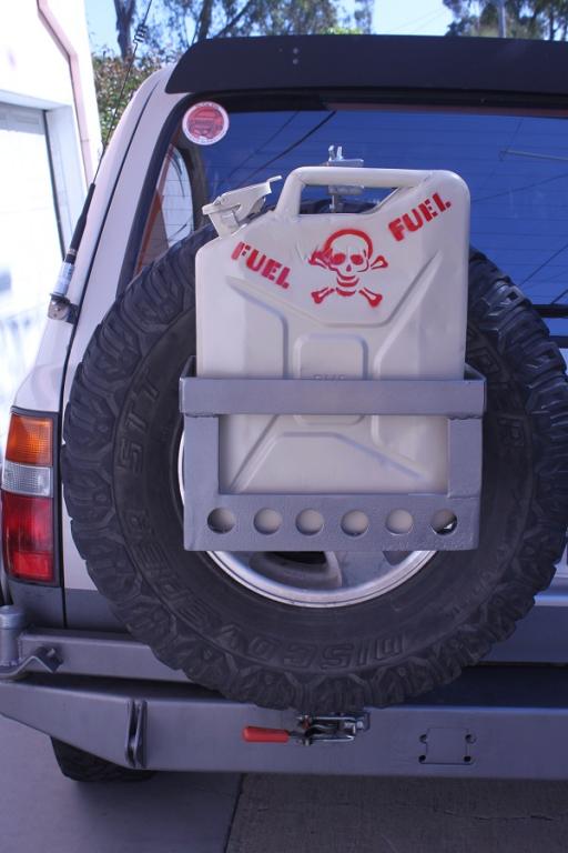
Yeah, I have to score a second can first and yeah I am not set-up at all to carry two in fact this will be my first time carrying my single can on a gas basket hitched into my tire swing.
Thought I would share my gas basket while it's nice and pretty before it's maiden run.

GasBasket-14.jpg


GasBasket-18.jpg


So where is Beale Mtn. is it labeled as "Camp Future" on your GPS file? That seems kind of far so thinking it is near Deer Springs.
 
Last edited:
I can carry extra cans on my rack. I was planning on bringing two but can bring 3-4 if needed. any suggestions on getting firewood up top and securing it down?:confused:
 
Back
Top Bottom