


- Joined
- May 8, 2008
- Threads
- 2,200
- Messages
- 2,200
Jump to Form »
The Bureau of Land Management is seeking public comment on a proposed High Desert Trail project that would designate approximately 810 miles of existing roads and trails across western Utah as part of a long-distance recreation route. The proposed trail would span Box Elder, Tooele, Juab, Millard, Beaver, Iron, and Washington counties and would utilize routes that are already open to the public.
The High Desert Trail would be open to both motorized and non motorized users. The route would provide opportunities for off-highway vehicle users, adventure travelers, cyclists, equestrians, hikers, and other recreationists to experience western Utah's diverse landscapes through a single signed corridor.
While the proposal doesn't create any new routes, the formal designation would make it extremely difficult for these routes to ever be closed again. Part of the proposal is also creating more opportunities for special recreation permits which would improve opportunities for organized events, and guided tours.
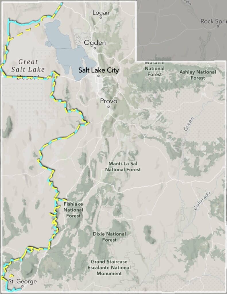
You can see in the map below and the interactive map, two alternatives being considered. The blue trail is Alternative B (preferred alternative) and the yellow trail is Alternative C. Alternative A is current management, or no formal designation. Alternative B is a longer trail (810 miles) and goes through a more scenic route and brings more economic benefit to different areas. The BLM should select Alternative B in order to provide the best recreation opportunities possible. The route goes near designated Wilderness in southern Utah however the bill that designated these Wilderness areas specifically stated that there cannot wilderness buffer zones created near these Wilderness areas. The BLM is within their jurisdiction to create this trail and BRC supports them in this designation.
The BLM is accepting public comments through June 16, 2026. Please make your voice heard and as always feel free to include your own personal message using the form below.
Continue reading...
The Bureau of Land Management is seeking public comment on a proposed High Desert Trail project that would designate approximately 810 miles of existing roads and trails across western Utah as part of a long-distance recreation route. The proposed trail would span Box Elder, Tooele, Juab, Millard, Beaver, Iron, and Washington counties and would utilize routes that are already open to the public.
The High Desert Trail would be open to both motorized and non motorized users. The route would provide opportunities for off-highway vehicle users, adventure travelers, cyclists, equestrians, hikers, and other recreationists to experience western Utah's diverse landscapes through a single signed corridor.
While the proposal doesn't create any new routes, the formal designation would make it extremely difficult for these routes to ever be closed again. Part of the proposal is also creating more opportunities for special recreation permits which would improve opportunities for organized events, and guided tours.
You can see in the map below and the interactive map, two alternatives being considered. The blue trail is Alternative B (preferred alternative) and the yellow trail is Alternative C. Alternative A is current management, or no formal designation. Alternative B is a longer trail (810 miles) and goes through a more scenic route and brings more economic benefit to different areas. The BLM should select Alternative B in order to provide the best recreation opportunities possible. The route goes near designated Wilderness in southern Utah however the bill that designated these Wilderness areas specifically stated that there cannot wilderness buffer zones created near these Wilderness areas. The BLM is within their jurisdiction to create this trail and BRC supports them in this designation.
The BLM is accepting public comments through June 16, 2026. Please make your voice heard and as always feel free to include your own personal message using the form below.
Continue reading...