


- Joined
- May 8, 2008
- Threads
- 2,200
- Messages
- 2,200
Note: The Bureau of Land Management in Utah has opened the Trail Canyon Travel Management Plan for public comment through July 22, 2026. There will be a public meeting held on July 9, 2026 from 6:00–8:00 p.m at the Kanab Center, 20 N 100 E in Kanab, Utah. If you're near the area, please show up!
Jump to form »
The Trail Canyon Travel Management Area (TMA) covers approximately 326,376 total acres in Kane County, Utah, of which 182,766 acres are BLM-administered. Bounded by the Dixie National Forest to the north, Zion National Park to the west, the Utah-Arizona border to the south, and Grand Staircase-Escalante National Monument to the east, this landscape is one of the most heavily visited recreation areas in the state, and visitation is rising every year.
The BLM's 2008 Kanab Field Office Resource Management Plan designated 473 miles of routes as OHV-Open within the TMA. After anti-access groups sued over this process, in 2017 a settlement agreement with those wilderness advocacy groups required the BLM to revisit those designations through a full travel management planning process. This Draft EA is the result of that settlement agreement.
The Alternatives:
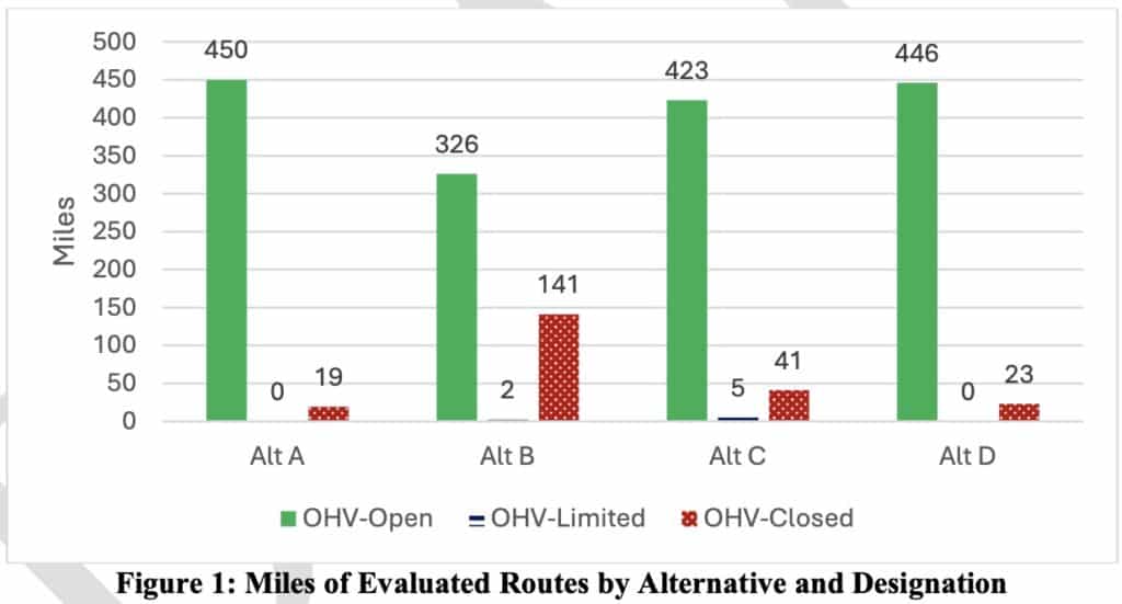
Alternative A — No Action (Current Management) 473 miles OHV-Open (96%) | 0 OHV-Limited | 19 miles OHV-Closed (4%). Continues the 2008 TMP. Closes only the 19 previously undesignated routes. Includes 24.5 miles of primitive routes within WSAs and 6.3 miles within BLM Natural Areas, all remaining open.
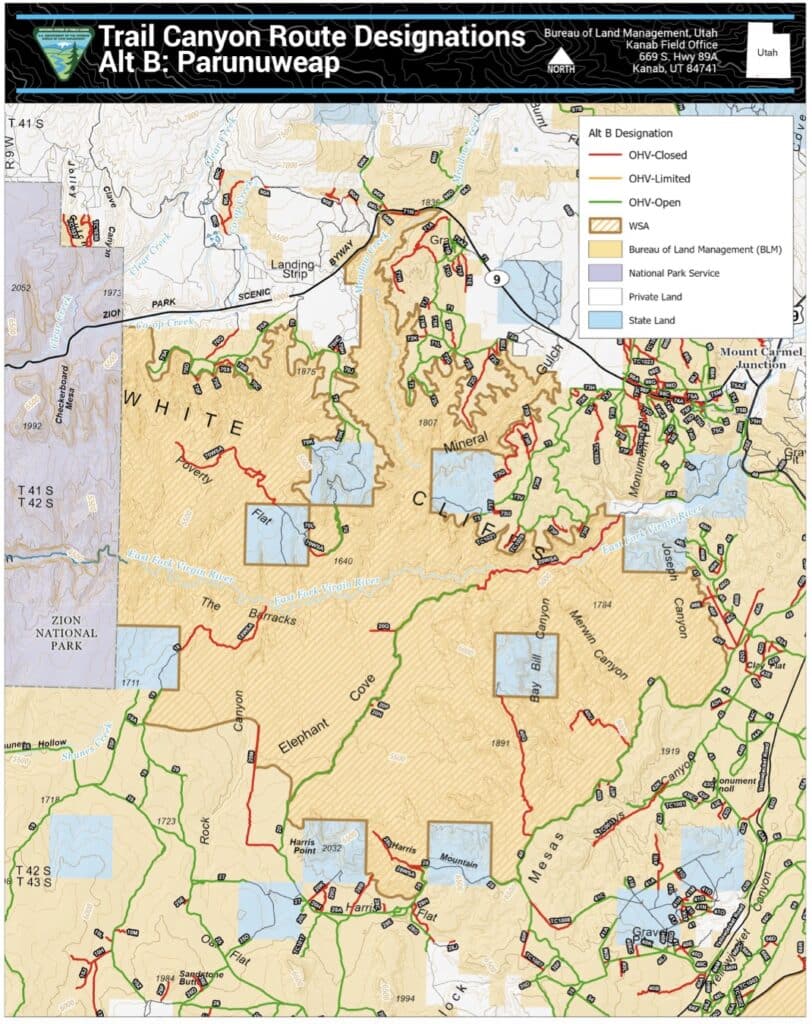
Alternative B — Conservation Emphasis 326 miles OHV-Open (71%) | 2 miles OHV-Limited (e-bikes only) | 141 miles OHV-Closed (29%). Prioritizes closures in WSAs, BLM Natural Areas, LWC units, T&E habitat, and riparian areas. All WSA primitive routes closed (24.5). All BLM Natural Area routes closed (6.3). This is the most restrictive alternative.
Alternative C — Balanced Access and Conservation 423 miles OHV-Open (91%) | 5 miles OHV-Limited (e-bikes only) | 41 miles OHV-Closed (8%) The "compromise" option. Keeps 91% of routes open. Introduces 5 miles of e-bike-only limitation.
Alternative D — OHV Access Emphasis 446 miles OHV-Open (95%) | 0 OHV-Limited | 23 miles OHV-Closed (5%) Maximizes open miles, keeping 95% of the network open. Closes only routes with acute resource conflicts. Retains nearly all WSA primitive routes. No OHV-Limited designations.
There are five wilderness study areas within the travel management planning area. Under Alternative D, none of the current open mileage that lies within the current WSAs will be closed. Oftentimes, if a route lies within a WSA, it is closed, which is the case for Alternative B. These routes existed before the WSA designation and should continue to remain open. Some of the proposed closures within Alternative D are to maintain wilderness values and characteristics. BRC consistently maintains that routes should not be closed outside of designated Wilderness.
Alternative B would close 141 miles of routes in total— 124 of which are currently open— nearly one-third of the entire network. Alternative B would eliminate access to some of the most valued recreation terrain in Kane County. Alternative B would close all primitive routes within the five Wilderness Study Areas in the TMA, all routes in BLM Natural Areas, and 81% of routes in lands with wilderness characteristics. These closures are not proportionate to documented resource impacts, and they would eliminate recreation opportunities that have been legally available for decades.
The EA's Purpose and Need section states that FLPMA "is to manage, develop, and enhance public lands under its jurisdiction in a manner that protects the resources, promotes the safety of all users, and minimizes conflicts among various users." However, FLPMA does not require the BLM to manage for user conflict. In fact, the route reports for the routes proposed for closure repeatedly state there is no known user conflict. The BLM should be managing to maximize user opportunities, not to minimize user conflict that doesn't exist in statute.
This plan is better than many travel management plans we have historically seen. We are thrilled that Alternative D only closes 4 miles of currently open routes. While Alternative A keeps the most routes open, it is the control alternative that the BLM uses to compare other alternatives. The BLM, in order to comply with NEPA will be selecting Alternatives B, C, D or a variation of one or more alternatives. For this reason, BRC supports a variation of Alternative D. We will be ground truthing the routes proposed for closure and also considering re-opening routes that were previously closed in order for this plan to comply with the EXPLORE Act to improve motorize recreation opportunities.
We need all motorized users to submit a comment to the BLM before July 22nd to let them know that motorized access is crucial.
Continue reading...
Jump to form »
The Trail Canyon Travel Management Area (TMA) covers approximately 326,376 total acres in Kane County, Utah, of which 182,766 acres are BLM-administered. Bounded by the Dixie National Forest to the north, Zion National Park to the west, the Utah-Arizona border to the south, and Grand Staircase-Escalante National Monument to the east, this landscape is one of the most heavily visited recreation areas in the state, and visitation is rising every year.
The BLM's 2008 Kanab Field Office Resource Management Plan designated 473 miles of routes as OHV-Open within the TMA. After anti-access groups sued over this process, in 2017 a settlement agreement with those wilderness advocacy groups required the BLM to revisit those designations through a full travel management planning process. This Draft EA is the result of that settlement agreement.
The Alternatives:
Alternative A — No Action (Current Management) 473 miles OHV-Open (96%) | 0 OHV-Limited | 19 miles OHV-Closed (4%). Continues the 2008 TMP. Closes only the 19 previously undesignated routes. Includes 24.5 miles of primitive routes within WSAs and 6.3 miles within BLM Natural Areas, all remaining open.
Alternative B — Conservation Emphasis 326 miles OHV-Open (71%) | 2 miles OHV-Limited (e-bikes only) | 141 miles OHV-Closed (29%). Prioritizes closures in WSAs, BLM Natural Areas, LWC units, T&E habitat, and riparian areas. All WSA primitive routes closed (24.5). All BLM Natural Area routes closed (6.3). This is the most restrictive alternative.
Alternative C — Balanced Access and Conservation 423 miles OHV-Open (91%) | 5 miles OHV-Limited (e-bikes only) | 41 miles OHV-Closed (8%) The "compromise" option. Keeps 91% of routes open. Introduces 5 miles of e-bike-only limitation.
Alternative D — OHV Access Emphasis 446 miles OHV-Open (95%) | 0 OHV-Limited | 23 miles OHV-Closed (5%) Maximizes open miles, keeping 95% of the network open. Closes only routes with acute resource conflicts. Retains nearly all WSA primitive routes. No OHV-Limited designations.
There are five wilderness study areas within the travel management planning area. Under Alternative D, none of the current open mileage that lies within the current WSAs will be closed. Oftentimes, if a route lies within a WSA, it is closed, which is the case for Alternative B. These routes existed before the WSA designation and should continue to remain open. Some of the proposed closures within Alternative D are to maintain wilderness values and characteristics. BRC consistently maintains that routes should not be closed outside of designated Wilderness.
Alternative B would close 141 miles of routes in total— 124 of which are currently open— nearly one-third of the entire network. Alternative B would eliminate access to some of the most valued recreation terrain in Kane County. Alternative B would close all primitive routes within the five Wilderness Study Areas in the TMA, all routes in BLM Natural Areas, and 81% of routes in lands with wilderness characteristics. These closures are not proportionate to documented resource impacts, and they would eliminate recreation opportunities that have been legally available for decades.
The EA's Purpose and Need section states that FLPMA "is to manage, develop, and enhance public lands under its jurisdiction in a manner that protects the resources, promotes the safety of all users, and minimizes conflicts among various users." However, FLPMA does not require the BLM to manage for user conflict. In fact, the route reports for the routes proposed for closure repeatedly state there is no known user conflict. The BLM should be managing to maximize user opportunities, not to minimize user conflict that doesn't exist in statute.
This plan is better than many travel management plans we have historically seen. We are thrilled that Alternative D only closes 4 miles of currently open routes. While Alternative A keeps the most routes open, it is the control alternative that the BLM uses to compare other alternatives. The BLM, in order to comply with NEPA will be selecting Alternatives B, C, D or a variation of one or more alternatives. For this reason, BRC supports a variation of Alternative D. We will be ground truthing the routes proposed for closure and also considering re-opening routes that were previously closed in order for this plan to comply with the EXPLORE Act to improve motorize recreation opportunities.
We need all motorized users to submit a comment to the BLM before July 22nd to let them know that motorized access is crucial.
Continue reading...