


- Joined
- May 8, 2008
- Threads
- 2,200
- Messages
- 2,200
Jump to form »
The Rio Grande National Forest has released its Draft Environmental Impact Statement for over-snow vehicle travel management, beginning the process of permanently designating where snowmobiles and other over-snow vehicles can operate across nearly 1.84 million acres of National Forest lands in southern Colorado. Public comments are due July 29, 2026 midnight EST.
This proposal is being developed under the Forest Service's Over-Snow Travel Management Rule (36 CFR Part 212, Subpart C), a regulation that has dramatically changed how winter recreation is managed on National Forests. Instead of allowing over-snow travel wherever snow conditions protect underlying resources, forests are now required to draw lines on maps and prohibit travel outside those designated routes and areas.
BlueRibbon Coalition is reviewing the proposal and preparing formal comments. While there are several positive components, there are also significant policy concerns that should be addressed before a final decision is made.
The Forest Service analyzed four alternatives.
Alternative 1 reflects current management, where approximately 1.84 million acres (75 percent of the forest) remain available for over-snow travel under the existing "open unless closed" approach.
Alternative 2 would be the most restrictive. It would eliminate all cross-country riding, designate only about 340 miles of routes, and convert approximately 1.45 million acres into restricted areas where over-snow travel would be limited to designated routes.
Alternative 3, which much of the document identifies as the agency's preferred alternative, would designate approximately 738 miles of routes and more than 1.2 million acres of open riding areas, while limiting travel through mapped big game winter range to designated routes. It also continues allowing over-snow travel through certain Special Interest Areas and Research Natural Areas where that use has historically occurred.
Alternative 4 provides the largest designated route system, with approximately 1,169 miles of roads and trails and more than 665,000 acres open to cross-country travel, but also creates nearly 392,000 acres of new non-motorized areas around locations such as Wolf Creek Pass, yurts, Nordic ski areas, and other recreation sites.
Overall, BRC believes Alternative 3 provides the strongest starting point because it preserves substantially more riding opportunities while continuing to allow access through certain Special Interest Areas and Research Natural Areas. However, several provisions from Alternative 4 that improve connectivity and route availability should also be incorporated into the final decision.
The following are the four alternative maps for the Saguache area:
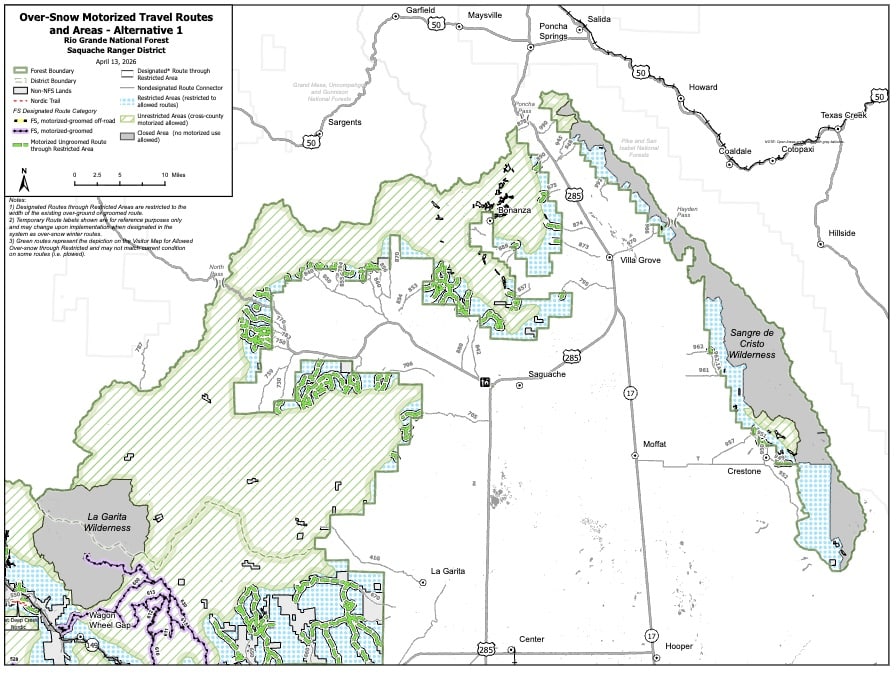
Saguache Alternative 1
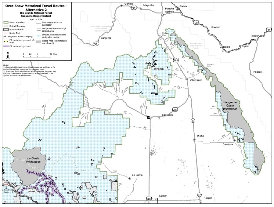
Saguache Alternative 2
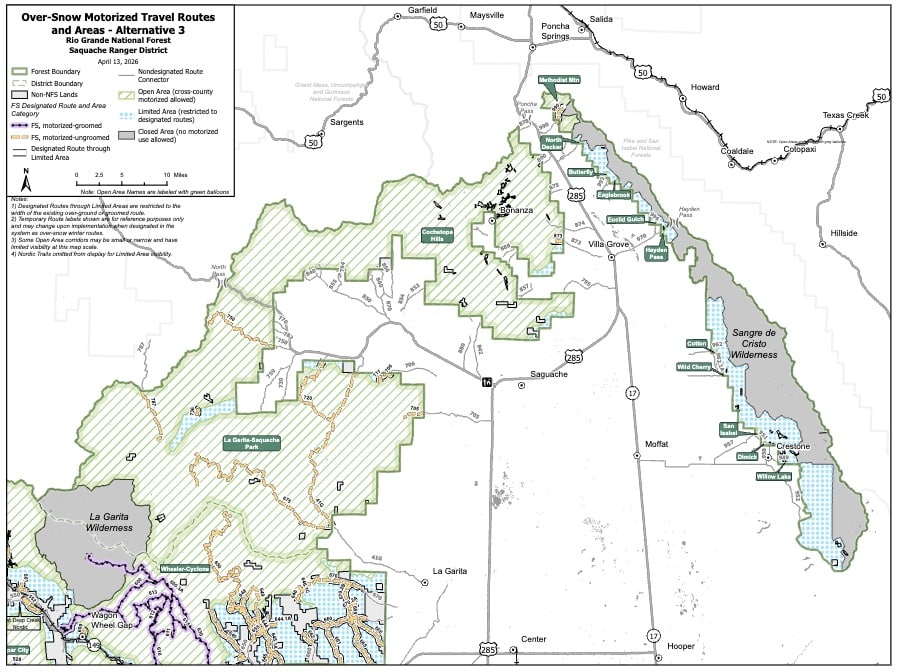
Saguache Alternative 3
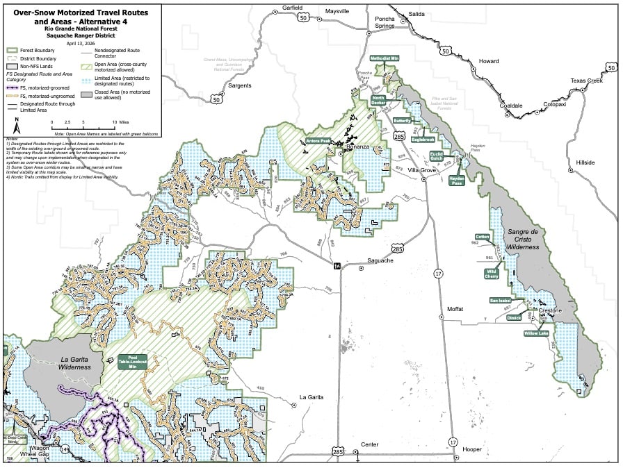
Saguache Alternative 4
The following are the four alternative maps for the Divide area:
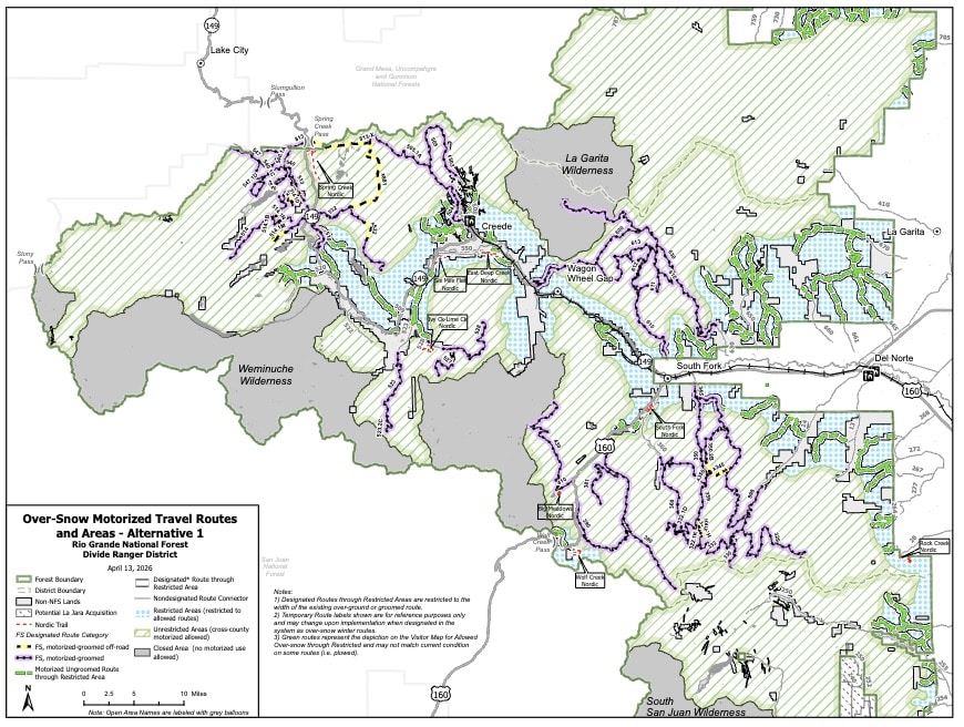
Divide Alternative 1
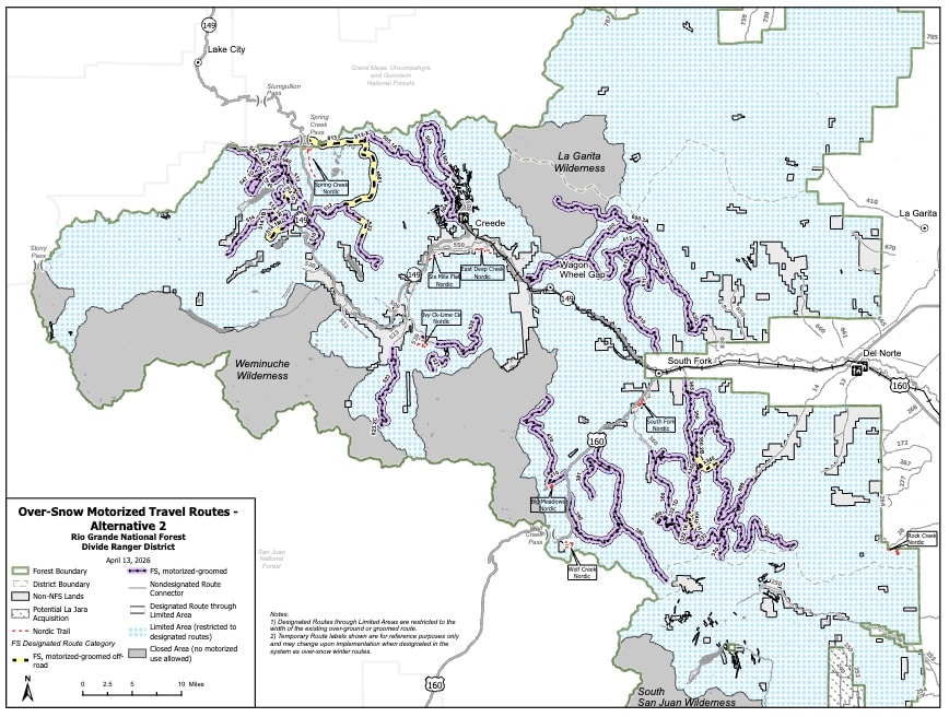
Divide Alternative 2
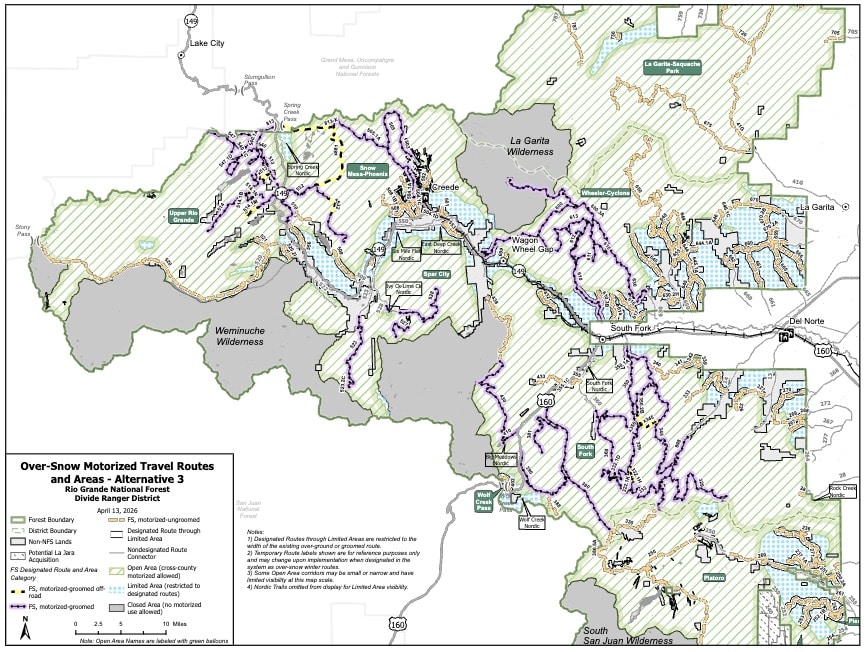
Divide Alternative 3
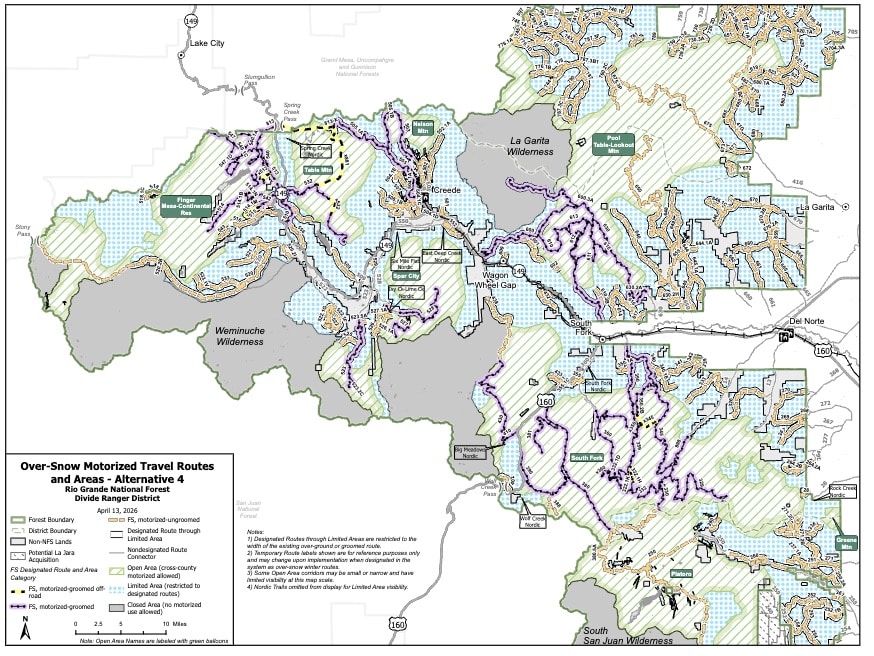
Divide Alternative 4
The following are the four alternative maps for the Conejos Peak area:
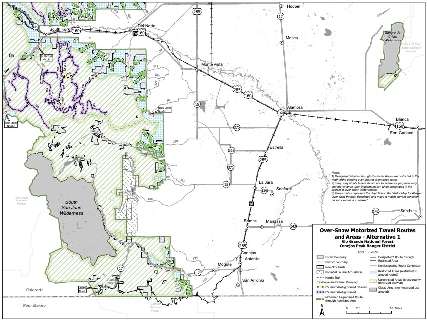
Conejos Peak Alternative 1
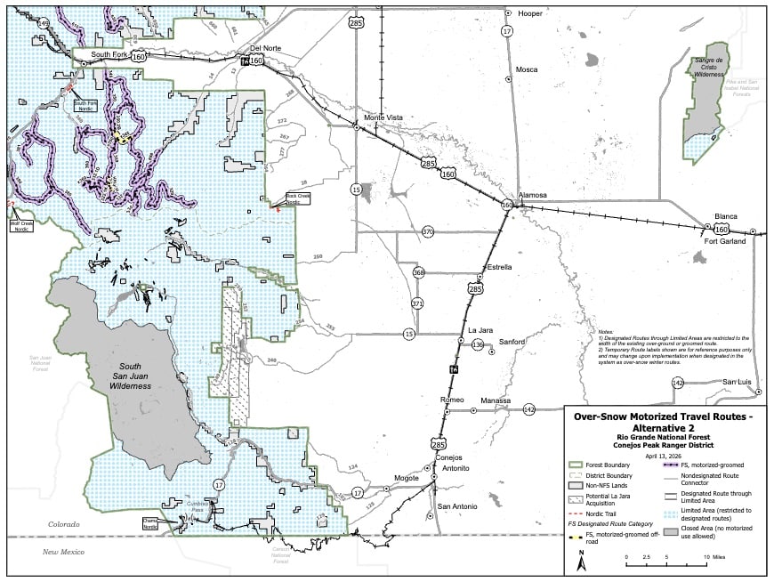
Conejos Peak Alternative 2
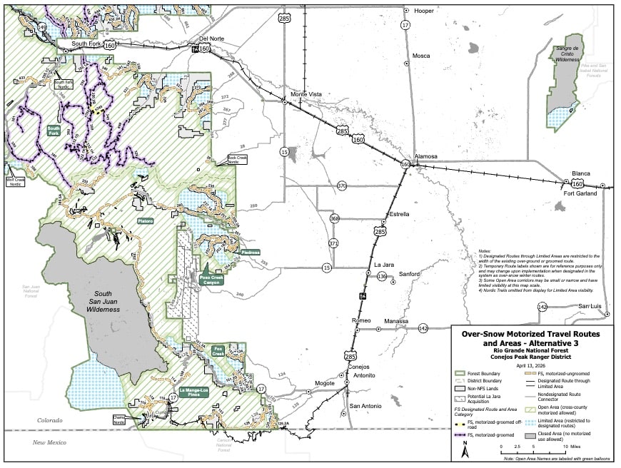
Conejos Peak Alternative 3
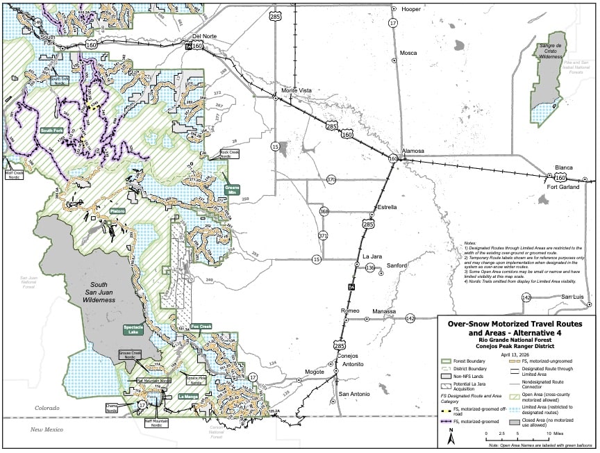
Conejos Peak Alternative 4
One of the first issues that stands out is an inconsistency within the Draft EIS itself.
The project abstract identifies Alternative 3, with portions of Alternative 4, as the preferred alternative. However, elsewhere in the executive summary the document identifies Alternative 2 as the preferred alternative. This inconsistency should be corrected before the Final EIS is released so the public clearly understands what the Forest Service is actually proposing.
A major driver behind the proposal is the Forest's Winter Recreation Opportunity Spectrum (ROS) mapping. The Forest Service uses these ROS classifications to determine where motorized and non-motorized recreation should occur, and those classifications largely dictate where snowmobiling will ultimately be allowed. These designations were finalized in 2024 and are now guiding this process. ROS is not a statutory mandate created by Congress. It is an administrative planning framework. Recreation Opportunity Spectrum classifications should help inform management decisions, not predetermine closures or create de facto buffer zones around wilderness or other special designations.
Alternative 2 creates buffer zones around already designed Wilderness which is illegal according to the legislation. The Forest Service states that no wilderness buffer zones are being proposed, and Congress has repeatedly made clear that wilderness designations do not create protective buffer zones outside their boundaries. In fact, Congress has included explicit "no buffer zone" language in numerous wilderness bills, including the Colorado Wilderness Act of 1980 (Public Law 96-560), which designated both the La Garita Wilderness and expanded the Sangre de Cristo Wilderness. Those laws state that Congress does not intend the wilderness designation to create protective perimeters extending beyond the wilderness boundary.
That principle should continue guiding this planning effort. Recreation opportunities outside designated wilderness should be managed according to applicable law and site-specific resource conditions—not because they are adjacent to wilderness.
The proposal also limits motorized use around areas identified as Recommended Wilderness, particularly in portions of the Sangre de Cristo Range.
Unlike designated wilderness, Recommended Wilderness is not created by Congress. It is an administrative recommendation made during forest planning and can be modified or removed through future planning decisions. The Forest Service is currently reconsidering how Recommended Wilderness is managed nationwide, making it inappropriate to permanently restrict snowmobile opportunities based on management direction that may soon change.
BRC believes these areas should be managed consistent with current policy changes and should not receive the same level of protection as congressionally designated wilderness.
One positive aspect of Alternative 3 is that it continues allowing over-snow travel through certain Special Interest Areas (SIAs) and Research Natural Areas (RNAs) where snowmobile use has historically occurred.
Special Interest Areas are designated for unique historic, geologic, botanical, or scenic values—not as motorized closures. Many of these areas have accommodated winter motorized recreation for decades without conflicting with the values they were established to protect. BRC supports maintaining that access.
The proposal establishes minimum snow depth requirements of 12 inches for general over-snow travel and 18 inches before trail grooming may occur.
These standards appear arbitrary and fail to account for the tremendous variation in snow conditions across the forest. Snow density, underlying vegetation, soil conditions, terrain, and vehicle type all influence whether travel can occur without resource impacts. A single forest-wide snow depth requirement is overly simplistic and could unnecessarily eliminate riding opportunities even when adequate protective snow exists.
The Forest Service should instead rely on site-specific conditions and local management discretion rather than imposing blanket depth thresholds users know their machines best and what is safe.
Use the tool below to submit your comments, please include your own personal information and experiences if you have them to make your comment even stronger.
Continue reading...
The Rio Grande National Forest has released its Draft Environmental Impact Statement for over-snow vehicle travel management, beginning the process of permanently designating where snowmobiles and other over-snow vehicles can operate across nearly 1.84 million acres of National Forest lands in southern Colorado. Public comments are due July 29, 2026 midnight EST.
This proposal is being developed under the Forest Service's Over-Snow Travel Management Rule (36 CFR Part 212, Subpart C), a regulation that has dramatically changed how winter recreation is managed on National Forests. Instead of allowing over-snow travel wherever snow conditions protect underlying resources, forests are now required to draw lines on maps and prohibit travel outside those designated routes and areas.
BlueRibbon Coalition is reviewing the proposal and preparing formal comments. While there are several positive components, there are also significant policy concerns that should be addressed before a final decision is made.
The Alternatives
The Forest Service analyzed four alternatives.
Alternative 1 reflects current management, where approximately 1.84 million acres (75 percent of the forest) remain available for over-snow travel under the existing "open unless closed" approach.
Alternative 2 would be the most restrictive. It would eliminate all cross-country riding, designate only about 340 miles of routes, and convert approximately 1.45 million acres into restricted areas where over-snow travel would be limited to designated routes.
Alternative 3, which much of the document identifies as the agency's preferred alternative, would designate approximately 738 miles of routes and more than 1.2 million acres of open riding areas, while limiting travel through mapped big game winter range to designated routes. It also continues allowing over-snow travel through certain Special Interest Areas and Research Natural Areas where that use has historically occurred.
Alternative 4 provides the largest designated route system, with approximately 1,169 miles of roads and trails and more than 665,000 acres open to cross-country travel, but also creates nearly 392,000 acres of new non-motorized areas around locations such as Wolf Creek Pass, yurts, Nordic ski areas, and other recreation sites.
Overall, BRC believes Alternative 3 provides the strongest starting point because it preserves substantially more riding opportunities while continuing to allow access through certain Special Interest Areas and Research Natural Areas. However, several provisions from Alternative 4 that improve connectivity and route availability should also be incorporated into the final decision.
The following are the four alternative maps for the Saguache area:
Saguache Alternative 1
Saguache Alternative 2
Saguache Alternative 3
Saguache Alternative 4
The following are the four alternative maps for the Divide area:
Divide Alternative 1
Divide Alternative 2
Divide Alternative 3
Divide Alternative 4
The following are the four alternative maps for the Conejos Peak area:
Conejos Peak Alternative 1
Conejos Peak Alternative 2
Conejos Peak Alternative 3
Conejos Peak Alternative 4
Confusion Over the Preferred Alternative
One of the first issues that stands out is an inconsistency within the Draft EIS itself.
The project abstract identifies Alternative 3, with portions of Alternative 4, as the preferred alternative. However, elsewhere in the executive summary the document identifies Alternative 2 as the preferred alternative. This inconsistency should be corrected before the Final EIS is released so the public clearly understands what the Forest Service is actually proposing.
Recreation Opportunity Spectrum Should Not Become a New Closure Tool
A major driver behind the proposal is the Forest's Winter Recreation Opportunity Spectrum (ROS) mapping. The Forest Service uses these ROS classifications to determine where motorized and non-motorized recreation should occur, and those classifications largely dictate where snowmobiling will ultimately be allowed. These designations were finalized in 2024 and are now guiding this process. ROS is not a statutory mandate created by Congress. It is an administrative planning framework. Recreation Opportunity Spectrum classifications should help inform management decisions, not predetermine closures or create de facto buffer zones around wilderness or other special designations.
No Wilderness Buffer Zones
Alternative 2 creates buffer zones around already designed Wilderness which is illegal according to the legislation. The Forest Service states that no wilderness buffer zones are being proposed, and Congress has repeatedly made clear that wilderness designations do not create protective buffer zones outside their boundaries. In fact, Congress has included explicit "no buffer zone" language in numerous wilderness bills, including the Colorado Wilderness Act of 1980 (Public Law 96-560), which designated both the La Garita Wilderness and expanded the Sangre de Cristo Wilderness. Those laws state that Congress does not intend the wilderness designation to create protective perimeters extending beyond the wilderness boundary.
That principle should continue guiding this planning effort. Recreation opportunities outside designated wilderness should be managed according to applicable law and site-specific resource conditions—not because they are adjacent to wilderness.
Recommended Wilderness Is Not Wilderness
The proposal also limits motorized use around areas identified as Recommended Wilderness, particularly in portions of the Sangre de Cristo Range.
Unlike designated wilderness, Recommended Wilderness is not created by Congress. It is an administrative recommendation made during forest planning and can be modified or removed through future planning decisions. The Forest Service is currently reconsidering how Recommended Wilderness is managed nationwide, making it inappropriate to permanently restrict snowmobile opportunities based on management direction that may soon change.
BRC believes these areas should be managed consistent with current policy changes and should not receive the same level of protection as congressionally designated wilderness.
Special Interest Areas
One positive aspect of Alternative 3 is that it continues allowing over-snow travel through certain Special Interest Areas (SIAs) and Research Natural Areas (RNAs) where snowmobile use has historically occurred.
Special Interest Areas are designated for unique historic, geologic, botanical, or scenic values—not as motorized closures. Many of these areas have accommodated winter motorized recreation for decades without conflicting with the values they were established to protect. BRC supports maintaining that access.
Arbitrary Snow Depth Requirements
The proposal establishes minimum snow depth requirements of 12 inches for general over-snow travel and 18 inches before trail grooming may occur.
These standards appear arbitrary and fail to account for the tremendous variation in snow conditions across the forest. Snow density, underlying vegetation, soil conditions, terrain, and vehicle type all influence whether travel can occur without resource impacts. A single forest-wide snow depth requirement is overly simplistic and could unnecessarily eliminate riding opportunities even when adequate protective snow exists.
The Forest Service should instead rely on site-specific conditions and local management discretion rather than imposing blanket depth thresholds users know their machines best and what is safe.
Use the tool below to submit your comments, please include your own personal information and experiences if you have them to make your comment even stronger.
Continue reading...