
How's the hood mod been working out? I'm still on the fence re: cutting/installing vents vs adding spacers between hood & hinges.
Navigation
Install the app
How to install the app on iOS
Follow along with the video below to see how to install our site as a web app on your home screen.
Note: This feature may not be available in some browsers.
More options
You are using an out of date browser. It may not display this or other websites correctly.
You should upgrade or use an alternative browser.
You should upgrade or use an alternative browser.
Builds GCRad1's 1992 ADV80 LAND CRUISER (4 Viewers)
- Thread starter GCRad1
- Start date
This site may earn a commission from merchant affiliate
links, including eBay, Amazon, Skimlinks, and others.
More options
Who Replied?- Joined
- Jul 23, 2008
- Threads
- 69
- Messages
- 912
- Location
- OC, CA, USA, EARTH SECTOR-28
- Website
- www.tdubclub.com
- Thread starter
- #622
Hello dcx13! Hope all is will with you sir!
The hood mod is doing what is suppose to do, release heat vs heat soaking the firewall. I don't know if '93up 80's make as much heat as the 91-92's, so technically I can not give you a true evaluation. But, i'm totally good with it! But yes, I totally understand how this is rather extreme. If you want to keep your classic clean look, don't do it! If you are simply looking for pure function, then go for it. At least try the "hot rod hood bump" as that is minimal. You will want to remove the rear rubber seal on the back for additional release so don't loose it!

The hood mod is doing what is suppose to do, release heat vs heat soaking the firewall. I don't know if '93up 80's make as much heat as the 91-92's, so technically I can not give you a true evaluation. But, i'm totally good with it! But yes, I totally understand how this is rather extreme. If you want to keep your classic clean look, don't do it! If you are simply looking for pure function, then go for it. At least try the "hot rod hood bump" as that is minimal. You will want to remove the rear rubber seal on the back for additional release so don't loose it!

How's the hood mod been working out? I'm still on the fence re: cutting/installing vents vs adding spacers between hood & hinges.
- Joined
- Jul 23, 2008
- Threads
- 69
- Messages
- 912
- Location
- OC, CA, USA, EARTH SECTOR-28
- Website
- www.tdubclub.com
- Thread starter
- #623
MOJAVE ROAD TRIP - Mojave Preserve - An Adventure Through Time
As stated in a previous post #617, I purchased the Mojave Road Guide back in 2011.
Six years later, FINALLY I am making this trip reality!
Here are some happy parents about to partake in a wife-husband only trip!
The girls see us off:
It's been a long time since we've had one of these trips! The dog and the girls
are working, schooling and taking care of the house for the weekend.
It's "please don't burn down the house!" as they see us off.
Set the odometer to zero-zero-zero.zero and GO! Disregard those other numbers up there, it's a 3FE UNDERpowered 80-Series and those little numbers up there just move around from time to time. Serious side, Yotamasters did a thorough go-over on the rig, but rarely anything on the motor gets touched, just all the accessories hanging off the motor like A/C, steering, belts and the sort that get the preventative maintenance treatment.
Like all trips for me, they start with paved tarmac. Our plan is to hopefully make it to Laughlin's
Avi Hotel as it's very close to the start of the Mojave Road. Our plan is to take three days to cover
the 140-miles of dirt. Yes, thats roughly 46-miles per day, but the third day is going to require
the transit home from Barstow. We actually get started a scratch later than we wanted to...
We are traveling to Laughlin via the 40-FWY and finally "throw in the pillow" just inside the Mojave
Preserve at the base or fence-line of Sweeney Granite Mountains off of Kelbaker Rd in Essex, CA.
We are roughly an hour from Laughlin, so we will not mess up our schedule.
While we will not be staying at the hotel, we get to test out our sleep-deck-system.
Next morning:
We wake with the early morning light. This getting old stuff sucks! We can't even sleep in like teenagers
even when we try!!! With no camp to break, it gives us a minute to walk around,
snaps some photos as the morning sun fills the sky and rises up to light up the mountain range.
The sun is now up and we hit the dirt road back to the freeway to Laughlin.
Back on HWY-40 Laughlin bound and breakfast awaits us over "dem-dare-hillz!"
As stated in a previous post #617, I purchased the Mojave Road Guide back in 2011.

Six years later, FINALLY I am making this trip reality!
Here are some happy parents about to partake in a wife-husband only trip!
The girls see us off:

It's been a long time since we've had one of these trips! The dog and the girls
are working, schooling and taking care of the house for the weekend.
It's "please don't burn down the house!" as they see us off.
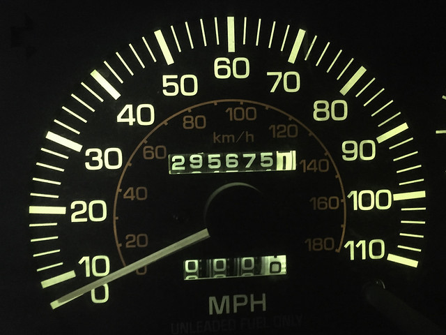
Set the odometer to zero-zero-zero.zero and GO! Disregard those other numbers up there, it's a 3FE UNDERpowered 80-Series and those little numbers up there just move around from time to time. Serious side, Yotamasters did a thorough go-over on the rig, but rarely anything on the motor gets touched, just all the accessories hanging off the motor like A/C, steering, belts and the sort that get the preventative maintenance treatment.

Like all trips for me, they start with paved tarmac. Our plan is to hopefully make it to Laughlin's
Avi Hotel as it's very close to the start of the Mojave Road. Our plan is to take three days to cover
the 140-miles of dirt. Yes, thats roughly 46-miles per day, but the third day is going to require
the transit home from Barstow. We actually get started a scratch later than we wanted to...

We are traveling to Laughlin via the 40-FWY and finally "throw in the pillow" just inside the Mojave
Preserve at the base or fence-line of Sweeney Granite Mountains off of Kelbaker Rd in Essex, CA.
We are roughly an hour from Laughlin, so we will not mess up our schedule.
While we will not be staying at the hotel, we get to test out our sleep-deck-system.
Next morning:

We wake with the early morning light. This getting old stuff sucks! We can't even sleep in like teenagers
even when we try!!! With no camp to break, it gives us a minute to walk around,
snaps some photos as the morning sun fills the sky and rises up to light up the mountain range.


The sun is now up and we hit the dirt road back to the freeway to Laughlin.


Back on HWY-40 Laughlin bound and breakfast awaits us over "dem-dare-hillz!"
Last edited:
- Joined
- Jul 23, 2008
- Threads
- 69
- Messages
- 912
- Location
- OC, CA, USA, EARTH SECTOR-28
- Website
- www.tdubclub.com
- Thread starter
- #624
continued: MOJAVE ROAD TRIP - Mojave Preserve - An Adventure Through Time
Traveling from the Sweeney Granite Mountains...
We stop in for breakfast at the Wagon Wheel Restaurant right on Route 66
in Needles, CA. This set's us up to travel on the Nevada side of the Colorado
River into Fort Mohave for fuel and supplies and jump back across to the California
side on Aztec Road right at the Avi Resort & Casino. Mile 0.0 is very close to
the Avi Resort and I was not sure if their was fuel at the hotel.
No, those are not shot glasses awaiting use... Those are old telephone pole insulators.
I'm sure there is a fancy particular name for them... I just know what they are used for.
In the parking lot, I came across Overland Bound Member: BR549-6866
HEY JT - Sorry, not making fun of you with the "BR549" (does anyone get it?)
It just pops into my head when I see numbers
identifying something.
I hope to have that number as my HAMM call sign! hehehe
We would not see him again on the trail until day-3 in Afton Canyon.
Once into Fort Mohave, we stop at WalMart for a few supplies and I spy this gem sitting in the
parking lot.
We pick up some hitch hikers and ask them if they know where they are going? Why yes! OK,
your on the dash and handing out directions! Oh that reminds me! Wonder if this website is still around:
One the Dash - YEP! http://www.onthedash.com/ My favorite page of the site is in honor of its namesake:
http://www.onthedash.com/Guide/_DashMounted// Sorry man, that's what you get here in my
thread... ALL THE ECLECTICISM'S! No, I personally do not own a Heuer watch or rally clock. Maybe a
stop watch somewhere deep in storage though... It would have been my fathers from our flat track
motorcycle racing days... OK, sorry, all that because of some frogs on the dash...
Oh you like that... OK, two more photos from WalMart with zero explanation.
OK, small explanations... one for graphics and the other has a cool meaning as seen here for
who its connected with if you dare care to explore: https://www.instagram.com/p/BbUuU5YDQio/
HEHEHE, sorry folks... ten photos and I have to hit the load button. Uncle Woody has us on
reduced chapters for reader comprehension and lord knows I can detract from within my own
post! More to come and it will be actual Mojave Road exploration!
Traveling from the Sweeney Granite Mountains...
We stop in for breakfast at the Wagon Wheel Restaurant right on Route 66
in Needles, CA. This set's us up to travel on the Nevada side of the Colorado
River into Fort Mohave for fuel and supplies and jump back across to the California
side on Aztec Road right at the Avi Resort & Casino. Mile 0.0 is very close to
the Avi Resort and I was not sure if their was fuel at the hotel.


No, those are not shot glasses awaiting use... Those are old telephone pole insulators.
I'm sure there is a fancy particular name for them... I just know what they are used for.


In the parking lot, I came across Overland Bound Member: BR549-6866


HEY JT - Sorry, not making fun of you with the "BR549" (does anyone get it?)
It just pops into my head when I see numbers
identifying something.
I hope to have that number as my HAMM call sign! hehehe
We would not see him again on the trail until day-3 in Afton Canyon.

Once into Fort Mohave, we stop at WalMart for a few supplies and I spy this gem sitting in the
parking lot.

We pick up some hitch hikers and ask them if they know where they are going? Why yes! OK,
your on the dash and handing out directions! Oh that reminds me! Wonder if this website is still around:
One the Dash - YEP! http://www.onthedash.com/ My favorite page of the site is in honor of its namesake:
http://www.onthedash.com/Guide/_DashMounted// Sorry man, that's what you get here in my
thread... ALL THE ECLECTICISM'S! No, I personally do not own a Heuer watch or rally clock. Maybe a
stop watch somewhere deep in storage though... It would have been my fathers from our flat track
motorcycle racing days... OK, sorry, all that because of some frogs on the dash...
Oh you like that... OK, two more photos from WalMart with zero explanation.


OK, small explanations... one for graphics and the other has a cool meaning as seen here for
who its connected with if you dare care to explore: https://www.instagram.com/p/BbUuU5YDQio/
HEHEHE, sorry folks... ten photos and I have to hit the load button. Uncle Woody has us on
reduced chapters for reader comprehension and lord knows I can detract from within my own
post! More to come and it will be actual Mojave Road exploration!
Last edited:
i like this ^^^^
New slogan "Yeti in my eighty"
- Joined
- Jul 23, 2008
- Threads
- 69
- Messages
- 912
- Location
- OC, CA, USA, EARTH SECTOR-28
- Website
- www.tdubclub.com
- Thread starter
- #627
Only when the 80 gets some sort of forced induction or motor upgrade. The 3FE might be a stump puller, but its not Yeti status... hehehe
New slogan "Yeti in my eighty"
- Joined
- Jul 23, 2008
- Threads
- 69
- Messages
- 912
- Location
- OC, CA, USA, EARTH SECTOR-28
- Website
- www.tdubclub.com
- Thread starter
- #628
continued:: MOJAVE ROAD TRIP - Mojave Preserve - An Adventure Through Time
We chose to drive to Laughlin to start the trail because that is how Dennis G. Casebier wrote
the book "Mojave Road Guide - An Adventure Through Time" and we wanted to follow it as
best possible. Give this page a read about Dennis G. Casebier.
Mile 0.0 West bank of the Colorado River across from the old Fort Mojave. Next time I will spend
a little more time on the other side at the actual site (now gone) but just to see the site.
I think this is the area that both the Mohave indians and early settlers crossed the Colorado.
From my inspection, ITS DEEP! But I think back in those day it didn't have this mote-berm
(flood control wall) we are standing on. There is mention in the book that the river could be up
to a half mile wide here, thus shallow enough to cross.
We made it here, but we have three days of desert travel ahead of us! The exciting part is, we
have three days! You could do it all in one-day, but would miss EVERYTHING and I have before.
This time we are going to see as much as we can! We only have to do about 46-miles per day!
Odometer from my house to Mile 0.0 on the Mojave Trail.
We are going to head that way! GO WEST THEY SAID! I did in 1985 in a '83 Nissan pickup from
Alabama to Oakland to finish college. The drive took three days. We take so much for granted.
The Mojave Indians traveled up through this wash. Settlers traveled this very route!
Mail traveled over this very route! Our curiosity had us looking up wagon travel and read that
wagons would cover 10-20 miles per day at best!
And they did it in these sandy conditions!
We are not even 10-miles into the trail and we see what looks like a cave.
Sure, we went to check it out! The ADV80 looks like a spec and we determine this a great
indian lookout location as its a big expansive view. To the right (further out of frame) they could easily see those
coming from the Colorado river.
As we have stopped, I use this moment to go ahead and air down. Only going down to 20.
I will usually run F18/R17. Maybe I was thinking about fuel consumption. Maybe I was thinking
about rocks...
We chose to drive to Laughlin to start the trail because that is how Dennis G. Casebier wrote
the book "Mojave Road Guide - An Adventure Through Time" and we wanted to follow it as
best possible. Give this page a read about Dennis G. Casebier.

Mile 0.0 West bank of the Colorado River across from the old Fort Mojave. Next time I will spend
a little more time on the other side at the actual site (now gone) but just to see the site.

I think this is the area that both the Mohave indians and early settlers crossed the Colorado.
From my inspection, ITS DEEP! But I think back in those day it didn't have this mote-berm
(flood control wall) we are standing on. There is mention in the book that the river could be up
to a half mile wide here, thus shallow enough to cross.

We made it here, but we have three days of desert travel ahead of us! The exciting part is, we
have three days! You could do it all in one-day, but would miss EVERYTHING and I have before.
This time we are going to see as much as we can! We only have to do about 46-miles per day!

Odometer from my house to Mile 0.0 on the Mojave Trail.

We are going to head that way! GO WEST THEY SAID! I did in 1985 in a '83 Nissan pickup from
Alabama to Oakland to finish college. The drive took three days. We take so much for granted.

The Mojave Indians traveled up through this wash. Settlers traveled this very route!
Mail traveled over this very route! Our curiosity had us looking up wagon travel and read that
wagons would cover 10-20 miles per day at best!

And they did it in these sandy conditions!

We are not even 10-miles into the trail and we see what looks like a cave.

Sure, we went to check it out! The ADV80 looks like a spec and we determine this a great
indian lookout location as its a big expansive view. To the right (further out of frame) they could easily see those
coming from the Colorado river.

As we have stopped, I use this moment to go ahead and air down. Only going down to 20.
I will usually run F18/R17. Maybe I was thinking about fuel consumption. Maybe I was thinking
about rocks...
Last edited:
- Joined
- Jul 23, 2008
- Threads
- 69
- Messages
- 912
- Location
- OC, CA, USA, EARTH SECTOR-28
- Website
- www.tdubclub.com
- Thread starter
- #629
continued::: MOJAVE ROAD TRIP - Mojave Preserve - An Adventure Through Time
It's one thing to read about artifacts in books and see photos, but to actually seek them out
and actually find them... that was super cool!
These petroglyphs are in Picture Canyon of the Dead Mountains as described in the book.
Yes, I will promote the use of this book because it is a great resource of history of the Mojave Road.
It was not written by the historical society, but rather by a man who came here via the military
from the midwest and became infatuated with the Mojave desert. So yes, I will refer to the
"Mojave Road Guide" book quite a bit!
After spending quite a bit of time in Picture Canyon, we finally move on. You can see the pointy
Jedediah Smith Butte in the background. It's a significant landmark for Piute Springs.
The original wagon way was to the left of Jedediah Smith Butte and up the wash into Piute Springs.
Due to the erosion, vehicles now go to the right and stay on top of the wash. As I'm not even a
full day into the trip, I've noticed how the wagons, who only followed the indian trails, tend to
stay low and follow the water flow. Travel patterns today are different than wagoners.
From within the walls of Piute Springs, you can see the Jedediah Smith Butte in the background.
It was a well made structure! Built by the white man and removed by the white man in our quest to
take a little piece of history for our own personal possession... "Each one of us has some impact
when we drive the Road. At a certain point that does no harm, and even does some good in preserving
the road. But at some point the numbers increase to where they do harm. Fort Piute has been
disappearing one rock at a time; the walls used to be much higher. No one goes out there to tear
down the fort, but they may take one rock as a momento, a trophy of their visit. Enough people
have done this that the walls are almost gone."
Read more: https://www.desertusa.com/desert-trails/dennis-casebier.html#ixzz4zMz3Qqbu
Fort Piute is a very nice refuge in the middle of the desert! We take a closer look down under the
trees and find water! I would put my MSR water filtration in there if I was in need!
Water is what makes these locations so vitally important across the desert. This was one of my
main interest in seeing as we traveled across the desert, I wanted to locate these water spots
that the indians knew of and provided their route of travel across the desert.
It's one thing to read about artifacts in books and see photos, but to actually seek them out
and actually find them... that was super cool!


These petroglyphs are in Picture Canyon of the Dead Mountains as described in the book.
Yes, I will promote the use of this book because it is a great resource of history of the Mojave Road.
It was not written by the historical society, but rather by a man who came here via the military
from the midwest and became infatuated with the Mojave desert. So yes, I will refer to the
"Mojave Road Guide" book quite a bit!

After spending quite a bit of time in Picture Canyon, we finally move on. You can see the pointy
Jedediah Smith Butte in the background. It's a significant landmark for Piute Springs.

The original wagon way was to the left of Jedediah Smith Butte and up the wash into Piute Springs.
Due to the erosion, vehicles now go to the right and stay on top of the wash. As I'm not even a
full day into the trip, I've noticed how the wagons, who only followed the indian trails, tend to
stay low and follow the water flow. Travel patterns today are different than wagoners.

From within the walls of Piute Springs, you can see the Jedediah Smith Butte in the background.

It was a well made structure! Built by the white man and removed by the white man in our quest to
take a little piece of history for our own personal possession... "Each one of us has some impact
when we drive the Road. At a certain point that does no harm, and even does some good in preserving
the road. But at some point the numbers increase to where they do harm. Fort Piute has been
disappearing one rock at a time; the walls used to be much higher. No one goes out there to tear
down the fort, but they may take one rock as a momento, a trophy of their visit. Enough people
have done this that the walls are almost gone."
Read more: https://www.desertusa.com/desert-trails/dennis-casebier.html#ixzz4zMz3Qqbu


Fort Piute is a very nice refuge in the middle of the desert! We take a closer look down under the
trees and find water! I would put my MSR water filtration in there if I was in need!

Water is what makes these locations so vitally important across the desert. This was one of my
main interest in seeing as we traveled across the desert, I wanted to locate these water spots
that the indians knew of and provided their route of travel across the desert.
Last edited:
- Joined
- Jul 23, 2008
- Threads
- 69
- Messages
- 912
- Location
- OC, CA, USA, EARTH SECTOR-28
- Website
- www.tdubclub.com
- Thread starter
- #630
continued:::: MOJAVE ROAD TRIP - Mojave Preserve - An Adventure Through Time
Fort Piute will be a place we come back to one day as the old wagon route goes on from here
now as a hiking-only trail called the Piute Hill Wagon Route. There on the other side it is said
you can see the wagon wheel tracks still in the rocks. THAT I WANT TO SEE!
We trot on down back to the designated route towards Rock Springs.
Next stop is the Piute Corral just up from the Piute Gorge.
This corral has been standing for some 130+ years and is indoctrinated into the Mojave Preserve
as an important historical artifact. It's great to see that no one has torn it down or "accidentally"
smashed it to bits!
We continue up from the corral to the edge of the gorge until we find a little spot that just looked
like a good spot. It was little exposed (like 360-degrees exposed) but it was on the edge of the
gorge. For some reason I thought we would be a lot closer to Caruthers Canyon, but that was
going to be too far of a stretch to make before we ran out of light. So we called this spot camp!
Camp was SO ROUGH setting up! HAHAHA!!! No tent to set up, just pop out the tables and set
up the grill! I'm digging our setup already! We find our spot along the ridge of the Piute Gorge.
Light was falling fast and we just wanted to get a decent spot and setup because it's DINNER TIME!!!
Breaking in the new Lodge cast iron griddle that fits perfectly on the Coleman!
Fort Piute will be a place we come back to one day as the old wagon route goes on from here
now as a hiking-only trail called the Piute Hill Wagon Route. There on the other side it is said
you can see the wagon wheel tracks still in the rocks. THAT I WANT TO SEE!

We trot on down back to the designated route towards Rock Springs.
Next stop is the Piute Corral just up from the Piute Gorge.

This corral has been standing for some 130+ years and is indoctrinated into the Mojave Preserve
as an important historical artifact. It's great to see that no one has torn it down or "accidentally"
smashed it to bits!


We continue up from the corral to the edge of the gorge until we find a little spot that just looked
like a good spot. It was little exposed (like 360-degrees exposed) but it was on the edge of the
gorge. For some reason I thought we would be a lot closer to Caruthers Canyon, but that was
going to be too far of a stretch to make before we ran out of light. So we called this spot camp!

Camp was SO ROUGH setting up! HAHAHA!!! No tent to set up, just pop out the tables and set
up the grill! I'm digging our setup already! We find our spot along the ridge of the Piute Gorge.
Light was falling fast and we just wanted to get a decent spot and setup because it's DINNER TIME!!!

Breaking in the new Lodge cast iron griddle that fits perfectly on the Coleman!


- Joined
- Jul 23, 2008
- Threads
- 69
- Messages
- 912
- Location
- OC, CA, USA, EARTH SECTOR-28
- Website
- www.tdubclub.com
- Thread starter
- #631
continued::::: MOJAVE ROAD TRIP - Mojave Preserve - An Adventure Through Time
We are stoked with our camp spot! We saw other mojave road explorers on the trail earlier,
but after we stopped a few clicks up from the trail, we didn't see or hear a peep out of anyone!
I find an old metal box that the whole bottom has rotted out and use it as my fire box.
It's October and the weather couldn't be any better! Cool enough, but I'm still in my shorts!
Wifey is warming her feet by the fire. Does it get any better than this?!
Next morning - BOOM! The sun is FULL VOLUME!
And like it, we are up and just taking our time. Make some coffee with my college roommate's
coffee company out of San Francisco - CENTO COFFEE SF.
Lets get down to business!
BREAKFAST! I'm going to need to walk the Mojave Trail eating like this!
Here are some views from our camp:
The edge of our camp had this spectacular view down into the Piute Gorge!

We are stoked with our camp spot! We saw other mojave road explorers on the trail earlier,
but after we stopped a few clicks up from the trail, we didn't see or hear a peep out of anyone!

I find an old metal box that the whole bottom has rotted out and use it as my fire box.

It's October and the weather couldn't be any better! Cool enough, but I'm still in my shorts!
Wifey is warming her feet by the fire. Does it get any better than this?!
Next morning - BOOM! The sun is FULL VOLUME!

And like it, we are up and just taking our time. Make some coffee with my college roommate's
coffee company out of San Francisco - CENTO COFFEE SF.
Lets get down to business!

BREAKFAST! I'm going to need to walk the Mojave Trail eating like this!
Here are some views from our camp:


The edge of our camp had this spectacular view down into the Piute Gorge!
- Joined
- Jul 23, 2008
- Threads
- 69
- Messages
- 912
- Location
- OC, CA, USA, EARTH SECTOR-28
- Website
- www.tdubclub.com
- Thread starter
- #632
continued::::: MOJAVE ROAD TRIP - Mojave Preserve - An Adventure Through Time
After breakfast and scouting around camp, we clean up and get back on the trail proper.
The vegetation is starting to change and I could just hang out and shoot photos all day, but we
would never get anywhere!
I've been truly impressed with these Falken Wild Peak A/T3's as I started on the
first generation. This third gen has earned it a snow flake rating, hence the siping
and I am sure there are other components to earn the snow-flake such as compound,
but either way, they are great "dual sports" tires for my daily driver!
These guys like the ride!
Between the MM39.5 mark, I miss my "slight right" and continue straight along the fence line
and in this really cool, but narrow wash. I can see the Goffs VORTAC GFS 114.4 ahead and
know I am headed in the right direction, but I know I will have to pop back over. But the wash
is cool! But I tell my wife I am going to hop out at the next spot as I want to stay the course of
the book.
Right as I find the spot to pop out, I see this truck sitting across the wash with his
front tires on the embankment and his bumper sitting under the sand at the base of the other
side. He can't go backwards, only forward, but he is only digging down... down... down.
As we come up, I see him walking back to his truck. He had been stuck for two hours already.
I dig my strap out, buckle him up and a gentle tug pulled him right out. he ask's how much he
owe's me and I promptly tell him to keep his money and pass the deed along. It's the desert way!
I'm just stoked that I took a wrong turn and found him!
We pop back across to the trail proper just in time to see the penny can! I've passed that a few
times and never even noticed it! But it was so crowed there, that we kept on truckin'
Nevada Southern Railway monument - Ivanpah - Lanfair Road
Google Map Location (hit the pink link)
I've passed this spot a few times too and never noticed the train tracks!
Much less this on top of the monument!
A small group passed through as we were hanging out here.
After breakfast and scouting around camp, we clean up and get back on the trail proper.


The vegetation is starting to change and I could just hang out and shoot photos all day, but we
would never get anywhere!

I've been truly impressed with these Falken Wild Peak A/T3's as I started on the
first generation. This third gen has earned it a snow flake rating, hence the siping
and I am sure there are other components to earn the snow-flake such as compound,
but either way, they are great "dual sports" tires for my daily driver!

These guys like the ride!
Between the MM39.5 mark, I miss my "slight right" and continue straight along the fence line
and in this really cool, but narrow wash. I can see the Goffs VORTAC GFS 114.4 ahead and
know I am headed in the right direction, but I know I will have to pop back over. But the wash
is cool! But I tell my wife I am going to hop out at the next spot as I want to stay the course of
the book.
Right as I find the spot to pop out, I see this truck sitting across the wash with his
front tires on the embankment and his bumper sitting under the sand at the base of the other
side. He can't go backwards, only forward, but he is only digging down... down... down.
As we come up, I see him walking back to his truck. He had been stuck for two hours already.
I dig my strap out, buckle him up and a gentle tug pulled him right out. he ask's how much he
owe's me and I promptly tell him to keep his money and pass the deed along. It's the desert way!
I'm just stoked that I took a wrong turn and found him!

We pop back across to the trail proper just in time to see the penny can! I've passed that a few
times and never even noticed it! But it was so crowed there, that we kept on truckin'

Nevada Southern Railway monument - Ivanpah - Lanfair Road
Google Map Location (hit the pink link)
I've passed this spot a few times too and never noticed the train tracks!
Much less this on top of the monument!


A small group passed through as we were hanging out here.

- Joined
- Jul 23, 2008
- Threads
- 69
- Messages
- 912
- Location
- OC, CA, USA, EARTH SECTOR-28
- Website
- www.tdubclub.com
- Thread starter
- #633
continued:::::: MOJAVE ROAD TRIP - Mojave Preserve - An Adventure Through Time
We carry our journey onward, but get distracted by a sign with little to no info!
ASHWELL ROAD - I can't find anything about this road! It's marked, but not traveled in quite some time!
Even as I sit here loading images and writing text, I've spent the better part of an hour looking
at links within Google not finding any real info. I've also parused Google Maps in satellite mode
looking to see where the 2-track goes to only see it fade out going north and running south
to the base of Hackberry Mountain. All I can think is that the family of Theophulis G. Ashwell has
placed it here marking the homestead of Ashwell as he is listed here: https://www.mdhca.org/local-history/homesteaders
O'well, I can't know everything...
But we scout it in both directions by foot, but only for a short distance.
That should be Hackberry Mountain in the background.
Further up the road, no info on this old place either...
Further onward:
But looking back... This section of the trail is very narrow and is quite a fun section.
Hey, I just randomly stop...
Next stop ahead - Camp Rock Springs:
Looking out onto Watson Wash. I have nothing to prove and I am not going to lie to you,
telling you that I drove down the steep and rutted section. I DID NOT! We actually went further up the road and backtracked back here as I wanted to see it from here as the settlers saw it.
We carry our journey onward, but get distracted by a sign with little to no info!

ASHWELL ROAD - I can't find anything about this road! It's marked, but not traveled in quite some time!
Even as I sit here loading images and writing text, I've spent the better part of an hour looking
at links within Google not finding any real info. I've also parused Google Maps in satellite mode
looking to see where the 2-track goes to only see it fade out going north and running south
to the base of Hackberry Mountain. All I can think is that the family of Theophulis G. Ashwell has
placed it here marking the homestead of Ashwell as he is listed here: https://www.mdhca.org/local-history/homesteaders
O'well, I can't know everything...

But we scout it in both directions by foot, but only for a short distance.

That should be Hackberry Mountain in the background.

Further up the road, no info on this old place either...

Further onward:

But looking back... This section of the trail is very narrow and is quite a fun section.

Hey, I just randomly stop...

Next stop ahead - Camp Rock Springs:

Looking out onto Watson Wash. I have nothing to prove and I am not going to lie to you,
telling you that I drove down the steep and rutted section. I DID NOT! We actually went further up the road and backtracked back here as I wanted to see it from here as the settlers saw it.
Last edited:
Stop telling people about the Mojave Preserve. It’s one of the last best kept secrets to non-crowded camping within a reasonable drive from LA. And the star gazing at night is legendary. And you can run from desert floor to over 5000ft elevation. And you can explore lava tubes. And you can explore epic desert trails. And the campgrounds have clean toilets and potable water. And, and, and. Looks like a fantastic trip!
- Joined
- Jul 23, 2008
- Threads
- 69
- Messages
- 912
- Location
- OC, CA, USA, EARTH SECTOR-28
- Website
- www.tdubclub.com
- Thread starter
- #635
"And the campgrounds have clean toilets and potable water."
WAIT - WHAT - WHERE?!?!?!?
We saw toilets at Afton Canyon... hehehe
WAIT - WHAT - WHERE?!?!?!?
We saw toilets at Afton Canyon... hehehe
Stop telling people about the Mojave Preserve. It’s one of the last best kept secrets to non-crowded camping within a reasonable drive from LA. And the star gazing at night is legendary. And you can run from desert floor to over 5000ft elevation. And you can explore lava tubes. And you can explore epic desert trails. And the campgrounds have clean toilets and potable water. And, and, and. Looks like a fantastic trip!
- Joined
- Jul 23, 2008
- Threads
- 69
- Messages
- 912
- Location
- OC, CA, USA, EARTH SECTOR-28
- Website
- www.tdubclub.com
- Thread starter
- #636
continued::::::: MOJAVE ROAD TRIP - Mojave Preserve - An Adventure Through Time
While the petroglyphs just outside Laughlin was on my "TO SEE" list...
This place was my #1 place to see - find.
In the Mojave Road Guide, while loading all the GPS coordinates, these two pages captivated me for
quite some time!
Pay special attention to the ink pen and the rock I'm drawing attention to in comparison to the
image below shot shot some 120-years before:
Notice how much rock is now exposed in the top image! That's 120-years of erosion in comparison
to the image just above! I so wanted to be able to pull the ADV80 into the location of the wagon
and Nissan pickup (35-years later) and (154-years later) that the wagon covered photo.
The sand wash was blocked for vehicle travel and I totally get it. It's what's behind me would have
every rock crawler and their mothers climbing through this wash and kinda'wrecking it.
So, I did the next best thing and took my book out and shot the comparison image. I think the
little canyon has collected more sand since 1983. I was expecting even more excavation. Very interesting!
We scramble up the wash to the other side of "the wall." While up here we noticed the rock house
on top of the hill. I didn't even notice it when we were down below.
From below, we missed it...
See the house up on the right? I was so enamored with finding my rock wall! I would have been
shot on the spot by the long picker! hehehe
From our trip, this has to be one of the nicest locations of residency we encountered!
As spectacular as Rock Springs is or was, the water supply was not always reliable.
So five miles down the road, they dug a well. The location is called Government Holes and has been
a reliable source of water for over 100-years!
The wind mill that pumps for Government Holes. There was a gunfight between two gunfighters
that took place here back in November 8th, 1825 On this day, November 11th, 2017, no gun fight.
While the petroglyphs just outside Laughlin was on my "TO SEE" list...

This place was my #1 place to see - find.

In the Mojave Road Guide, while loading all the GPS coordinates, these two pages captivated me for
quite some time!

Pay special attention to the ink pen and the rock I'm drawing attention to in comparison to the
image below shot shot some 120-years before:

Notice how much rock is now exposed in the top image! That's 120-years of erosion in comparison
to the image just above! I so wanted to be able to pull the ADV80 into the location of the wagon
and Nissan pickup (35-years later) and (154-years later) that the wagon covered photo.
The sand wash was blocked for vehicle travel and I totally get it. It's what's behind me would have
every rock crawler and their mothers climbing through this wash and kinda'wrecking it.

So, I did the next best thing and took my book out and shot the comparison image. I think the
little canyon has collected more sand since 1983. I was expecting even more excavation. Very interesting!

We scramble up the wash to the other side of "the wall." While up here we noticed the rock house
on top of the hill. I didn't even notice it when we were down below.
From below, we missed it...

See the house up on the right? I was so enamored with finding my rock wall! I would have been
shot on the spot by the long picker! hehehe

From our trip, this has to be one of the nicest locations of residency we encountered!
As spectacular as Rock Springs is or was, the water supply was not always reliable.

So five miles down the road, they dug a well. The location is called Government Holes and has been
a reliable source of water for over 100-years!

The wind mill that pumps for Government Holes. There was a gunfight between two gunfighters
that took place here back in November 8th, 1825 On this day, November 11th, 2017, no gun fight.
"And the campgrounds have clean toilets and potable water."
WAIT - WHAT - WHERE?!?!?!?
We saw toilets at Afton Canyon... hehehe
Mid Hills Campground
Facilities
Pit toilets, trash receptacles, potable water, fire rings, picnic tables; no dump station or utility hookups. Firewood is not available in the park.
Campgrounds - Mojave National Preserve (U.S. National Park Service)
- Joined
- Jul 23, 2008
- Threads
- 69
- Messages
- 912
- Location
- OC, CA, USA, EARTH SECTOR-28
- Website
- www.tdubclub.com
- Thread starter
- #638
Midfat, THANK YOU for that info!
Luckily for me, my wife and daughters are totally aquatinted with the Cleanwaste Portable Toilet.
Luckily for me, my wife and daughters are totally aquatinted with the Cleanwaste Portable Toilet.

Mid Hills Campground
Facilities
Pit toilets, trash receptacles, potable water, fire rings, picnic tables; no dump station or utility hookups. Firewood is not available in the park.
Campgrounds - Mojave National Preserve (U.S. National Park Service)
- Joined
- Jul 23, 2008
- Threads
- 69
- Messages
- 912
- Location
- OC, CA, USA, EARTH SECTOR-28
- Website
- www.tdubclub.com
- Thread starter
- #639
continued:::::::: MOJAVE ROAD TRIP - Mojave Preserve - An Adventure Through Time
We make our way out of Government Holes and onto a well groomed government road...
But we prefer the two track. We see (on the map) what has to be a part of the
original trail, but it is a short section. We still prefer it for the remote feeling of it.
And this spot nets us the following views from atop the roof rack.
ALL THAT FROM ONE SPOT! Gotta'love the Mojave Preserve!
Not much words can do here and that was the 10-photo limit.
We make our way out of Government Holes and onto a well groomed government road...


But we prefer the two track. We see (on the map) what has to be a part of the
original trail, but it is a short section. We still prefer it for the remote feeling of it.
And this spot nets us the following views from atop the roof rack.


ALL THAT FROM ONE SPOT! Gotta'love the Mojave Preserve!
Not much words can do here and that was the 10-photo limit.
- Joined
- Jul 23, 2008
- Threads
- 69
- Messages
- 912
- Location
- OC, CA, USA, EARTH SECTOR-28
- Website
- www.tdubclub.com
- Thread starter
- #640
continued::::::::: MOJAVE ROAD TRIP - Mojave Preserve - An Adventure Through Time
Crossing the Kelso Cima (paved) Road , we come across a historical marker for our dirt road:
The Mojave Road Historical Marker - Location Google Map Link.
98-miles of dirt so far since we've departed the Colorado River in Laughlin, Nevada.
These guys have had a great ride, but we have arrived to their community homestead, Frog Tribute.
Those chose their family spot within the claim.
The family spokesperson told us we must move on if we are to see our stars at our next camp.
Underneath the mailbox:
Spotted my team and Service Shop - YOTAMASTERS!
For them, my ADV80 travels in service confidence!
Add my companies sicker:
Yea, I work in the toy industry... AXIAL.
Also at the Frog Shrine is this slowly growing bobblehead monument.
And this 4X4 monument:
Some demented dad stole his daughters dolls.... hehehe
Approaching Soda Lake, the light of day is falling fast!
We make camp on the west side of the lake as we want to see it in the day light.
Crossing the Kelso Cima (paved) Road , we come across a historical marker for our dirt road:

The Mojave Road Historical Marker - Location Google Map Link.

98-miles of dirt so far since we've departed the Colorado River in Laughlin, Nevada.


These guys have had a great ride, but we have arrived to their community homestead, Frog Tribute.

Those chose their family spot within the claim.

The family spokesperson told us we must move on if we are to see our stars at our next camp.
Underneath the mailbox:

Spotted my team and Service Shop - YOTAMASTERS!
For them, my ADV80 travels in service confidence!
Add my companies sicker:

Yea, I work in the toy industry... AXIAL.

Also at the Frog Shrine is this slowly growing bobblehead monument.
And this 4X4 monument:


Some demented dad stole his daughters dolls.... hehehe


Approaching Soda Lake, the light of day is falling fast!

We make camp on the west side of the lake as we want to see it in the day light.
Similar threads
Users who are viewing this thread
Total: 5 (members: 0, guests: 5)